2009-07-17 49 -122
| Fri 17 Jul 2009 in 49,-122: 49.1505235, -122.7551496 geohashing.info google osm bing/os kml crox |
Contents
Location
The geohash is on a large wooded lot interrupting 168A Street in a subdivision east of Fleetwood. Transit accessible via the Fraser Highway.
Participants
Planning
I am taking a bus that will get me to the geohash about 4:15 p.m. - Robyn
I will attempt to make it after a farewell lunch for my mom. If I come, I'll be there around 4:30pm. --Fbfree 17:35, 17 July 2009 (UTC)
Expedition
Robyn
T-Rex and I took a bus to Skytrain, a packed Skytrain car to Surrey Central and a bus along the Fraser Highway. It's amazing how fast the kilometres fly by when you're not walking, but I recognized every intersection we passed. I got off at 168th and crossed at the light, following it around the curve looking for 168A Street. How many streets would you expect to find between 168th and 168A?
I found the first bit of 168A, dead-ending neatly against a concrete barricade and a completely overgrown vacant lot. I looked for a trail in. There's always a trail in, from kids playing. But I couldn't find one. Kids these days must play video games instead of building forts in the middle of bramble patches. I stepped around the barricade into the woodlot. There were a lot of brambles. I pushed a few aside and managed a few steps into the mess. The GPS said the geohash was 23 metres ahead. And it looked as if the terrain dipped down into a creek or a gully. I seem to be operating on a very low stupidity distance today, as I did not plunge into the brambles.
I retreated and walked around a couple of blocks to find the other broken end of 168A Street. You know how in the video game Sim City if you built too many roads or too few roads the inhabitants were unhappy, but you could achieve a goldilocks situation by building a road and bulldozing ever second square? Sometimes I think the Surrey city planners played too much Sim City in school. You can play video games and play in brambles. There's balance for everything.
The other end of 168A Street ended similarly against the woodlot. Here there was a small sort of path into the trees, created by a resident dumping garden waste into the lot. It was like a bridge over the brambles created by lawn clippings matted around sticks. It was a little precarious, as I could tell that the supporting grid of sticks could snap dropping me an unknown distance to the real ground. And it was also 23 metres from here to the geohash. The geohash was exactly in the middle of the bramble patch. Figures.
Now that I was a little ways in from this side, I could see that over to the left the trees were thicker, so thick that there wasn't enough light for brambles to grow thickly underneath. I headed that way, around the trees, under the strands of brambles until there were eight metres remaining. That was my stupidity distance. T-Rex and I both received a few scratches, but we made our way into the thicket.
After I reached the point and had taken a few pictures, I heard someone say, "How did you get in there?" And then geohashing took one step closer to being exactly as I imagined it would be, as I sat in the middle of a huge mess of almost impassible thorns, and a stranger crawled in and introduced himself.
Fbfree
As I checked the geohash coordinates Friday, I was hoping for an easy Vancouver geohash on Sunday as I would be able to drag along my parents before my mother's flight to Germany. No luck. With the complete absence of other accesible hashes, I decided to venture Friday immediately after a lunch out for my mother's trip.
As usual, my mother wondered why I should need to travel to the far reaches of -gasp- Surrey. Given the sweltering temperatures, I almost agreed, put decided 2L of water packed and sunscreen would be sufficient. The route was 50km over varied terrain, and two notable hills. After an hour, I had to stop by the side of the road to cool myself off. After 2 hours, I ran out of water along rural 80Ave. After passing up a corner store with no bicycle parking or bikes allowed inside, I decided to sweat out the last 5km.
This last 5km was on a heavily use rural road with no shoulders demanding much attention. As I approached a slight climb over the last kilometer, I was stopping every minute to let cars pass by my lethargic pace. I was very happy to reach the hash near the end of 168B St. ... oops. I travelled up a public trail at the end of the block, into a school yard, and around to the north of the hashpoint. Seemingly inaccesible over a fence and bush, I travelled back find the end of 168A St, south of the point. After over a kilometer of extra cycling (to travel less than 100m, love suburbia!) I heard a rustling far in the bush. "Do I hear someone from the internet over there?"
Both
After posting a comic and an Internet was here notice and posing for a few more photos we crawled back out of the thorns and went to the nearest Tim Horton's for iced drinks and Timbits. Robyn learned about what happened to Fbfree when he was two. Fbfree learned what television show (other than Star Trek) overly shapes Robyn's worldview. A discussion over alternative geohash navigational methods occured. The Timbits were eaten. T-Rex was gazed at in awe by small children. It was a successful geohash.
Fbfree
On the return trip, I went over the Golden Ears Bridge for the first time, not just on it (see 2009-06-14_49_-122). I had initially missed the cyclists onramp as the signage pointed left to the ramp just prior to an intersection. I think too much like a car.
Photographs
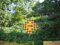
The vacant lot full of brambles

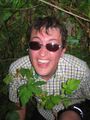
Robyn in the middle of the lot
Fbfree coming to meet her
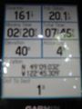
Proof of coordinates
T-Rex disobeying parking regulations
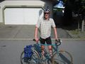
Fbfree and his bicycle


