2009-07-21 49 8
| Tue 21 Jul 2009 in 49,8: 49.0130359, 8.4742963 geohashing.info google osm bing/os kml crox |
Contents
Location
The hashpoint is located in Karlsruhe between the suburbs Hagsfeld and Grötzingen. It is on or just next to a newly build section of a main road (Bundesstraße 10). Google Map's satellite pictures do not show this road - you can only guess some preparations for the road works. The normal Google Map shows the road but the accuracy is doubtful.
The road is part of the Nordtangente (Karlsruhe's city-wiki, in German), a highly controversial planned highway through the northern suburbs of Karlsruhe and also through the Hardtwald, the large forest north of karlsruhe. So far, only this part has been built, connecting the Autobahn A5 with roads nearby, as the new onramp "Karlsruhe Nord".
Participants
Plans
Fluxkompensator plans to be there around noon about 9:45 in the morning (if bikes are allowed on that road).
- I just made the very spontaneous decision to try this one, too. So I'll be starting the expedition right now, attempting a tron geohash (there via Elfmorgenbruchstraße, back via Hagsfeld) Koepfel talk 16:10, 21 July 2009 (UTC)
Expedition by Fluxkompensator
Expedition by Koepfel
Live from the Expedition
- the road is in fact not bike accessible, so my tron attempt ended approx. 900 m from the hash, as I can't cross the autobahn here. I now will try to find a bridge further south. Koepfel talk 16:47, 21 July 2009 (UTC)
- after a larger non-tron detour, the gps zeroed in at 19:20. Fluxkompensators marker was found, right next to the highway. Koepfel talk 17:25, 21 July 2009 (UTC)
Report
I left my home at 18:15, hoping for a quick expedition, after all, the distance as the bird flies is only. 2.4 kilometers. So I biked through Rintheim, crossed an area of allotment gardens and two rail tracks.
Unfortunately, when I approached the crossing, where I would have to turn right, I could already see, that there was a blue highway sign on that road (blue signs on german roads = Autobahn or Schnellstraßem = no bikes). this sign, to be more exact, called Kraftfahrtsstraße - only motor vehicles) So I turned right here, to a small forest path, which lead me under the highway bridge. The problem: The 900 meters seperating me from the Hashpoint included the highly used A5 Autobahn. No way to cross that, except the bridge I was standing under, a bridge, where cars were allowed to go 100km/h. Too fast for bikes.
Since I already crossed my path several times now, I gave up on the tron achievement and decided to take the closest bridge I knew: The Durlacher Allee bridge, at the next Onramp. Also the tram crosses there, so I knew I could get across that bridge for sure. Another bridge was just a few hundred meters north, but I didn't know that :|
At the Durlacher Allee bridge is was finially able to cross the Autobahn. Distance to hashpoint was about 2 km then.
Through more gardens and field, I cycled back to the Hash adn was finially able to park my bike, when the GPS pointed 90° into a grass field.
So far, I biked 9.8 kilometer. Given that the direct distance was only 2.4 kilometers, you can calculate the ratio (slalom factor, as Ekorren calls it) of 4.08. Since this is seemed pretty much, I decided to draw a map, which is linked below (the tracklog).
Standing at the grass field, I was able to see, that someone had already trampled some plants before me. Fluxkompensator seemed to have reached the point, too. So I entered the field, including some very thick and large and more importantly thorned bushes and, after climbing the dam the road was built on, my GPS showed a distance of 0 meters. The Hashpoint was right at the barrier of the road. Luckily, since cars were going about 100km/h at this sectiion, no way one could step on the road.
Fluxkompensators marker was also found, so I added my name and took photos.
Instead of fighting through the thorns again on the way back, I chose to take the stair on a nearby bridge.
On the way back, via Hagsfeld, I saw a street sign of the Schäferstraße. Sounds familiar. The 2009-07-01 49 8 Geohash was here. Revisited!.
After stopping in Hagsfeld to buy some groceries, I arrived home at about 20:00.
Tracklog of the complete expedition. Parts of the ride were not recorded by a GPS, but drawn in Google Earth as I remembered it.
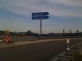
Not suitable for bikes
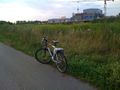
after a larger detour: Parking at the hashpoint
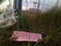
Coordinates reached
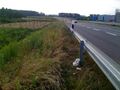
Not the nicest location imaginable


