2009-08-28 52 12
| Fri 28 Aug 2009 in 52,12: 52.5643503, 12.9348701 geohashing.info google osm bing/os kml crox |
Location
Today's location is in a field near Zeestow, not far from Wustermark.
Country: Germany; state: Brandenburg (EU:DE:BB); district: Havelland; municipality: Brieselang
Participants
Plans
Expedition
ekorren
I started from Berlin in the late morning. I only had checked a few bus timetables, as trains usually go often enough, and took a bus to the station of Jungfernheide first. There I was taught a little bit better, since there wasn't any train due for more than half an hour - soI took the subway to get to Spandau and try again, as there are considerably more train lines passing there.
I had aimed at a train going for Brieselang, as I believed that there would be a bus to Zeestow shortly after the train arrives. And immediately dropped that plan when I found that I just had run into one of the famous Berlin transport breakdowns - the train I wanted to catch was announced being at least 20 minutes late (which would make me miss the bus). Is there a Plan B? Of course there is - you never should go without one. Wustermark station would be close enough to walk to the hash even if there was no bus at all.
And Wustermark was easily reachable just now, as they just announced a train going there, being only 40 minutes past its schedule. I assured an old woman that the train would also stop at Dallgow, which meant that she would get there 20 minutes earlier than her daughter expected her - and probably much earlier than taking the train she actually had planned...
The train I was on now should have been going to Rathenow, but was cancelled due to the delay after Wustermark. However, that's where I wanted to get off anyway, and I was actually earlier there than expected, so I was probably the only one who just got off the train without getting pissed off. Checked for buses and found one that wouldn't bring me much closer to the hash, but save me the ugly first part of the walk along the main road.
The bus dropped me off at a large road junction from where I walked through the industrial area and for the road to the hash. That road was more like an agricultural track, in rather bad condition, a rough surface of sand, gravel and - ancient cobblestone. Actually, this looked probably was an historical road which lost importance to building new ones, but must have been there at least since the 19th century. It crossed an abandoned railway track and then went out into the fields.
That railway has once been an electrified main line, and its history is worth noticing. Having been built in 1902 mostly to allow freight trains to go around Berlin instead of passing the city, it gained particular importance after a locomotive driver broke through the Berlin wall by not stopping his local train at its final destination and instead running on until he reached Western Berlin. After that, the border crossing point he had used was closed, the tracks removed, and the trains rerouted via this line to another border crossing point, where a breakthrough was made utterly impossible by changing the track layout. In the mid-1990s, after the old line had been restored, no more trains needed to be rerouted this way and the line was abandoned. Still, many leftovers are visible from the hash, as neither sleepers nor overhead wire masts, gravel or many other installations have been removed.
Now, back on track. The hashpoint was 55 m into a harvested field which was easy to walk on. I picked up a stick, made a small flag from a piece of paper, found the point, left the flag, made photos and left. There wasn't anything to do there anyway.
I went back to the "road" and decided not to go back to Wustermark on the shortest way but instead walk into Zeestow, the village the hashpoint belonged to. The road was called Kirschenweg (cherry way) and now I saw, and smelled, why that was so - it was lined with lots of trees that well may be cherries (although most of the fruits were yellow), or maybe only some earlier plantations were cherries. Nowadays, noone cared about them anyway. The fruits were overripe, fell off, and fermented happily on the ground. Add in the fact that the locals obviously like to take advantage of the secluded area by illegally disposing of garbage on both sides of the road, you can imagine the smell. Or maybe you can't, in which case you probably are lucky.
Got to Zeestow a few minutes too late to catch a bus to Wustermark, but there would be another one to the train station of Brieselang soon. When the bus came, with only the driver but no passengers, it stopped almost in the last moment, and I was greeted with large surprise:
I almost forgot to stop. There's never anyone getting on here! Well, I did get on the bus. And the driver immediately got curious. What the heck does someone do at Zeestow?! I tried to explain geohashing to him. He seemed to understand how it works; although didn't really get why one would do that. But, anyway: That's a lot more than most people understand, isn't it?
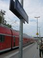
Arriving at Wustermark
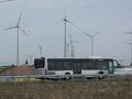
This bus didn't take me very far, but a bit closer to the hash
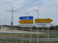
To the right for the industrial area of Zeestow
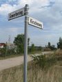
Cherry way to the hash
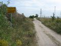
This actually is a public road
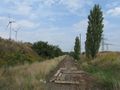
Abandoned railway track with some history
The hash
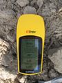
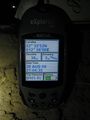
Coordinates reached
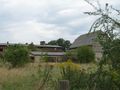
Mostly abandoned farm buildings at hash village


srs0, thepiguy, Danatar
This expedition is part 4 of an ultrahash done on the way to the big 2009-08-29 52 13 meetup, and was on day 1 of a 3-day consecutive geohash:
- Day 1:
- Day 2:
- Day 3:
The three hashers continued from 51 11 towards 51 12 in a weary state. The driver, Danatar, was starting to get hungry by the time they neared Berlin, so they kept their eyes open for a restaurant along the autobahn. Having found one, they proceeded to look for the exit, and completely missed it. As such, they just continued along the way to the hashpoint and left food for afterwards.
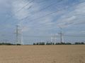
Upon nearing the hashpoint, the first thing they noticed was the power station in the background. Srs0, having not seen the maps, voiced concern that the hashpoint may be inside the fenced off area. Danatar, who had made many plans, said otherwise, and sure enough he was correct.
They continued to drive towards the hashpoint along an extremely small dirt road, before stopping because the ruts in the road were so deep that it wasn't safe to continue with Danatar's car. They were only around 200-300m away, so they got out and started walking. Right where they started, they found an unopened bottle of sparkling wine, which thepiguy picked up, declaring it to be "hash wine!" A bit down the path, the road changed from dirt to ancient cobblestone, which was surprising as it looked to be at least a couple hundred years old! Ekorren should have more to say on this, since he saw it in the daylight.
Once the gps pointed perpendicular to the path, we left it and entered the harvested field, walking towards the power station. Thepiguy went ahead, doing his gps dance, while Danatar and Srs0 followed more slowly. Something faintly white in the dark caught srs0's eye, and he stared at it for a few seconds before announcing "something's here" to Danatar. Upon hearing this, Danatar promptly pulled out his camera and used the flash to light the "something", and there it was! Proof of Ekorren's visit! We had found a little flag that he left!
The three geohashers gathered around the little flag and took a bunch of pictures. Ultrahash completed! They then continued to a truck station for some quick food, and then Berlin, where Danatar dropped srs0 and thepiguy off at a hostel at around 00:30 on the 29th of August. He then proceeded to relet's place, reaching it after a total distance of 705 km.
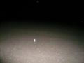
There's something white there!
Ultra hash!
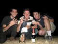
Wooooo!
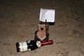
A better picture of the note.
relet enjoying his glass of hashwine on New Year's Eve 2009/2010.


