2009-09-05 48 7
| Sat 5 Sep 2009 in 48,7: 48.9588002, 7.8889434 geohashing.info google osm bing/os kml crox |
Location
In a field near Schoenenbourg.
Participants
Plans
Part two of a double hash. The plan was to take the train to Wissembourg (arriving at about 14:30) and then bike about 12 kilometers to the Hash.
Expedition by Koepfel
Report
< Part 1 After arriving at Karlsruhe Hauptbahnhof (Main Station) from my expedition to Mühlacker, I only had a few minutes to change to a local train to Winden, where I changed to another local train to Wissembourg, where I arrived at 14:30.
As I exited the train in Wissembourg, it began to drizzle. I began to remember 2009-04-18 49 7, where I biked 2*15km through pouring rain from Wissembourg to Niederschlettenbach. I think the eastern 8th meridian hates me.
When exiting Wissembourg, southwards. I noticed, that for some reason, biking up a slight incline seemed extremely difficult. I was going to find out the reason in about one hour.
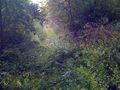
About a kilometer later, I made my first mistake. After taking the wrong turn and biking to Steinseltz, I was too far east from my planned route, a paved road through Riedseitz, Ingolsheim and Schoenenbourg. And because of that, I ended up on some field path, which's condition became more and more worse, also due to increasing rain.
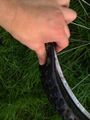
Eventually, I got back to the (paved) main road, at the village of Ingolsheim. On the pavement, without the dense grass, I could now see what happened: Apparently, I was riding with a half-flat tire for a while now, which went completely flat on the muddy field paths. I inflated it again to check if the air stayed inside, which, at first seemed to be tha case. As I still had about 30 minutes left, the 16:00 meetup was still somewhat possible. So I went on hashwards.
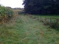
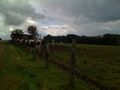
Shortly before Schoenenbourg (Hash village), I turned right, on a path I though would lead me to the Hash. Wrong path again. At the end of the path, I found a grass field.
Pushing the bike on that field, 16:00 approached. Over 1.5 kilometers to go. Damn. The tire was completly flat again. I inflated it and kept pushing the bike.
About 20 minutes later (minus reinflating the tire), I checked the GPS again. Still 1.2 kilometers? So there I was. 1.2 kilometers from the Hash, GPS/camera7phone's battery almost empty, flat tire, no maps, in a country which's language I barely speak, over 12 kilometers from the closest train station that i was sure to be in operation on Saturdays. Should I continue? The battary robably won't survive a larger GPS dance (as the Hash seemed to be in a field). Also, pushing a bike with a flat tire for 12 kilometers will take a while, adding to the time needed of finding tha Hashpoint.
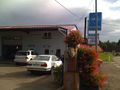
So I gave up. The way back home would be hard enough. I walked back to Schoenenbourg. Take a bus home? I did find a stop, but no service on weekends. Hitchhike? Probably won't work, considering the bike. As I stood in the village, a man asked me, what I was looking for. Fortunately, he spoke a bit of German, so, with the little French I knew, I was able to explain my situation. He said, there was a train station in a village about 2 kilometers away, but wasn't sure, if trains ran on Saturdays, Then, he pointed me to a garage at the end of the village, which might still be open.
Luckily, it was open. At the garage, we could see, that patching the tire was impossible, as it had about 6 or 7 holes. As it was a garage for cars, they had no new tube, but one of the workers was able to drive to the next village and get one for me. Even though they most likely won't read this report, thanks for your help.
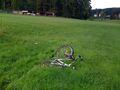
After buying a new tube, biking was easy again. I thought about still doing the hashpoint, but I was getting tired and simply wanted to go home.
By 18:10 I was back in Wissembourg, from where I took the 18:33 train. I arrived home at about 20:00.
Koepfel earned the Train wreck consolation prize
|
path (decent condition)
path (bad condition)
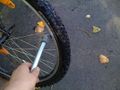
Reinflating the tire in Ingolsheim
16:00. Not quite there yet (1.5 kilometers to go)