2009-12-14 52 13
| Mon 14 Dec 2009 in 52,13: 52.4375906, 13.5675740 geohashing.info google osm bing/os kml crox |
Location
A tree on a strange meadow in Adlershof near Mahlower Straße.
Participants
Plans
As we are both studying in Adlershof, JUB and I will definitely visit this geohash. We are planning to go there after our Analysis IIIa lecture, that means we will be there at about 15.15h. Maybe we try to drag along some other mathematicians, JUB is thinking about going as a hobbit. Anybody else coming? --HiroProtagonist 16:12, 12 December 2009 (UTC)
I will definitely drop by, but 15.15h is rather improbable. I'll have to visit either in the morning or in the night. Would you people be interested in 2009-12-13 53 13? -- relet 17:15, 12 December 2009 (UTC)
- I'm really busy at the moment, so I don't have time for longer trips :( If we're there first on monday, I'll try to leave a hashmarker! --HiroProtagonist 00:47, 13 December 2009 (UTC)
Expedition
JUB and Hiro
After our analysis lexture JUB and I set out for geohashing in Adlershof. The hash was a mere [distance] from our campus, so we gad decided to walk, but we were convinced by a caring fellow student not to do so barefoot, so the idea of a hobbit geohash was dropped (which later turned out to be a very good decision)
We made our usual way to the Sbahnhof and then continued through the wild, unknown and thus mysterious north-east of Adlershof. But for the beginning there were not too many adventures awaiting us, just some really cute street names caught our attention ("Süßer Grund" - "Sweet cause"/"sweet ground") and soon afterwards we stopped at a Netto to buy some sweets - a good strengthening for the way ahead! :)
After an encounter with the Adlershof youth underneath the railway bridge, we were finally close to the hash: We left the Glienicker Straße and went into the small Mahlower street. Where it turned left we heroically went straight on, follwoing a small foot path along a derelict barricaded building that strongly remembered me of the place where the matrix doesn't work properly in Animatrix. Behind that building lay the alleged meadow, which turned out to be a field of reed, two meters high, not really on dry ground. But this could of course not detain us - especially since we were wearing shoes :)
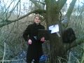
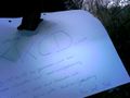
So we followed the trail through the reed, the ground was often covered with ice and/or water, but somehow we made our way, and luckily just following the trail lead us to the tree in the middle of the field, where the hash point happened to lie according to Google Maps :) At the tree we quickly made a hashmarker and then started the tedious task of trying to make a photo of us. My camera still happens to be broken and unfortunately didn't have another miracle healing today. My mobile phone did produce photos, but not very nice ones, so finally JUB took out his laptop and we used it's webcam to first accidentally produce a video and then some photos, which I hope will turn out nice...
After completing the photo task we soon made our way back (it was damn cold there!) and walked all the way back to the Erwin-Schrödinger-Zentrum (our university building) and thus made up for a roughly 6.5 km walk geohash - if google measured correctly...
All in all, a wet and cold, but definitely interesting geohash! :)
Tracklog
[1] - I tried to teach google which way we went, the last part (from the road to the tree) is missing.
Photos
Pictures from Hiros mobile:
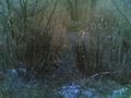
The "path" through the reed
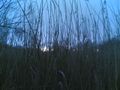
We're in the reed field now
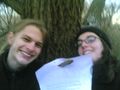
Stupid grin
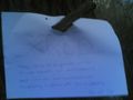
Our hashmark
better pics with a laptop webcam?!
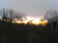
Sunset :)
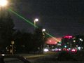
An ufo in Adlershof


Pictures from JUBs webcam:

Stupid grin, quite definately!
Our marker
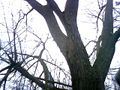
THE T(H)REE...
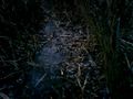
Beware! Icy puddles on our way...


Ribbons
Hiro and JUB earned the Walk geohash Achievement
|
Hiro and JUB earned the (subjective) Frozen Geohash
|