2009-12-22 48 8
| Tue 22 Dec 2009 in 48,8: 48.9489331, 8.4932909 geohashing.info google osm bing/os kml crox |
Contents
[hide]Location
In a field between Karlsruhe's suburbs Stupferich and Palmbach.
Participants
Plans
Attempting a public transport tron geohash, which, to my knowledge, has never been done before. I've wanted to do that since the day the achievement was created, seeing as being bound to a few possible routes makes this the most challenging form of tron geohashing. I've planned several tron-train geohashes before, but this is the first one that might actually work.
The plan, here's a map for those who want to follow [1]
- Leave house to the north, walk to the tram stop Sinsheimer Straße, take S2 to Hagsfeld Bahnhof (not on the map, since the map only includes buses)
- Take bus 31 (the red line on the right part of the map) to Durlach Friedhof, here's the exact route [2]
- Walk from Friedhof the the stop Durlach Turmberg. The 31 actually goes there, but uses the same road as bus 23, which I'm going to take, for a few meters, which would invalidate the tron geohash. As I have 18 minutes waiting time at Turmberg anyway, this won't cost me any additional time.
- Take bus 23 from Durlach Turmberg to Stupferich Pfefferacker, map [3]
- Walk from there to the hashpoint, which is in a field, enter the field from the north, leave to the south, continue walking to the stop Stupferich Auf der Römerstraße.
- Take bus 47, map [4], back to Zündhütle, from there take tram 2 and tram 4/S2 back home, enter house from the south.
All buses involved go every 20 minutes during the day, trams every 10, so timing isn't an really an issue. I plan to leave my home at about 8:00, arriving at Stumpferich at 8:56.
- Weather update: After lot's of snow and temperatures of -10°C over the weekend, it's now around 1°C and raining like hell. So inb4 drowned rat geohash and muddy shoes (again). Leaving in 30 minutes. 06:16, 22 December 2009 (UTC)
Report
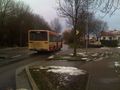
I left my home at about 8:00. It was raining heavily when I left, but by the time I boarded the S2 from Sinsheimer Straße to Hagsfeld, the rain stopped. In Hagsfeld, I exited the S2, went through the tunnel under the railway line. All possible without crossing one's path. Bus 31 arrived on time, I entered. On my way to Durlach, I passed the 2009-07-21 49 8 hashpoint by a few hundred maters, tried to take a photo from the bus, didn't work out too well.
Exiting the bus at Durlach Friedhof, I walked to the stop Durlach Turmberg. Tram 1 terminates here, as do several bus lines. Like bus 23, which would take me to Stupferich.
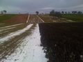
By 8:56, I arrived at Stupferich Pfefferäcker. Now to the hash.Now to the hash. I walked along a few field paths. As the ground was still frozen, most of them were covered with a layer of ice, so better walk on the grass. Eventually, the GPS pointet 90° into the field. The field was muddy, but luckily I was prepared this time, wearing more water- and mudproof shoes. I reached the coordinates at about 9:15. The hashpoint was located between two fields, one of which was grown with plants.
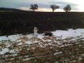
I built a snowman, wrote a marker, took photos. The snowman looks a little bad, as there wasn't that much (clean) snow left. Also, I was trying to create a live broadcast from the hashpoint via ustream's iphone application, the network coverage wasn't good enough though, so I took a short video and uploaded it at home. And here it is.
On the way back, I crossed the A8 autobahn, towards the bus stop Auf der Römerstraße. By 9:50, I was back on the bus, line 47 into town. I exited at Zündhütle and changed into tram 2. From there, I rode to Durlacher Tor, changed into tram 5 and arrived in Rintheim by 10:36 and walked home.
Koepfel earned the Tron achievement
|
Geohashing by bus
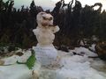
He does look evil.


