2010-01-09 60 10
| Sat 9 Jan 2010 in 60,10: 60.3445266, 10.7865796 geohashing.info google osm bing/os kml crox |
Location
Nedre Hovra, Norway
Participants
Plans
Drive as close as it gets. Then plough through some 200m of snow. Do not get confused this time.
Expedition
The short story: Drove as close as I got. Hiked for some 6km. Ploughed through some 800m of snow. Only got slightly confused.
The long story: After the glorious defeat yesterday, and from the looks of the hashpoint, I did not have much hope. So, I decided to at least come better prepared. I'm not sure what that means, but at least I had made sure to download the coordinates and some maps into the geohashdroid this time. And to double the trousers I wore with a waterproof outer shell.
The hashpoint lay in what the excellent Norwegian maps (free maps, down to cadastre level! free high-resolution pictures of the whole country!) described as a myr. A moor. However, with the temperatures still at -15°C, there wouldn't be much risk of sinking. The only issue was that the closest track was about 250m from the hashpoint. I wasn't sure how realistic it would be to plough through the snow for such a distance.
I started my expedition at 11am like on the other days (friendly hotel has breakfast buffet open until 11). It was a little less of a drive than yesterday, but roughly in the same direction. Again, I drove along snowy, iced, and gritted roads, onto something that seems to be the high road to Gardermoen - where the low road is the toll tunnel.
I then reached a place where my map indicated a smaller road branching from said high road. I was greeted by a boom (raised), a sign (indicating that you should keep your dogs on a leash, if I am not mistaken), a dog sled track and an otherwise uncleared road. Still 3km to go. This looks even worse than yesterday.
But, not wanting to be as easily thwarted again, I prepared my backpack, pulled the elastic bands on my clothing into snow-tight mode, and started hiking up the dog trail. I realized that, unless the trail would come really close to the geohash, I would be in bad luck. I also soon realized that walking on just barely compressed snow was rather tiring. I hoped that no one would mind me walking in their sled tracks anyway, knowing that the so-called cross-country skiers (the ones that run in runs, instead of cross-country) are rather picky about their runs.
Well. What happens when you throw a city boy at a mountain of snow? He fails. Or he'll learn. I decided for the latter, and using my vast knowledge of sled physics (or at least my vast imagination of sled physics), decided that:

- Given a roughly equal weight distribution on the sled
- And a driver who tries to stay upright on his sled
- And differences in the density and depth of the snow below the sled
Both runners of the sled would sink into the snow to different depths - which in turn is being compensated by the equilibrium of the driver. Which means that the side which does not sink as deep into the snow (because the snow is denser), gets additional weight from the driver. Meaning that the snow, which is already less compressible, would get even denser on that side because of the extra weight.
Hence, instead of walking in the middle of the track, I soon decided to walk always on the slightly more elevated side of the track. And doubled the hiking speed. Yay for science!
The track followed on and on. The road I had on the map was branching occasionally, but except for one branch where some skiers seem to have gone cross-country (yay for real skiers), and a lot of elk and rabbit tracks, there was not much of a decision I could take. It was follow the tracks, or turn back. Fortunately, the tracks were going right where I wanted them to.
A decent hike of 3km later, I hit a road. I was a bit pissed off by the fact that, after all this effort, there would be suddenly a... let's call it a car-wide track in the snow. However, that apparently gave me the opportunity to approach the hash from either side. It was either: Go 300m to the left, and plough through the snow for about 300m. Or follow the road for another km around the next bend, and approach the hash from the north.. maybe 200m of ploughing.
I decided that if it was going to be ploughing through the snow, I could as well get to it now. I further snow-proofed my gear (I hoped) and found a track of elk origin leading into the snowy woods.
In the elk tracks, I sank about knee deep into the snow. My legs stayed dry and warm. My feet stayed dry and warm. It was slightly exhausting. Sanity check passed.
The elk tracks soon became a bit too erratic for my taste. I tried my luck with the fresh snow. I sank about hip deep. After a bit of ploughing, I reached a rock. My legs were dry and warm. My feet were dry and a bit coldish. It was mighty exhausting. But the coordinates came closer. I decided to postpone the next sanity check for just a little while.
While erring through the landscape, and always a bit uphill, the snow depth varied between knee deep and armpit deep. The latter ofter causing me to turn back and find a better approach. I quickly learned that woods, while looking like an obstacle, were often more navigable than open plains. Or even valleys. I was rather warm overall. The legs were fine. The left foot was dry. The right shoelace got open and I got some snow in the shoe. I removed it, resulting in a rather cold foot and a wet sock. It got a bit numb. But nothing to worry about, really. Core temperature was fine, and the geohasher panting. 80m to go.
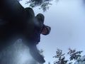
30m. I eyed a large tree to head for. About half way, the GPS jumped to 8m. Seeing no obstacles around me, I decided to skip the usual GPS dance for another silly manoeuvre. I grabbed my other camera, set it on time-and-repeat mode, and began throwing it in the air - the cheap way to get some random aerial shots. 42 photos later, I decided that I was cold and wet enough and headed back.
I must have covered a distance of about 500m to the hash - the return was a rather straight line - partly because it was downhill now, partly because I decided that the fading sun was a better point of orientation than the androidish compass.
I reached the road, and the sled trail back. 3km to go. About half way, I heard voices. Wondering if I would now get shouted at by a dog-sled owner for using his tracks. However, as I heard no dogs, I trodded on. A little later, I saw a figure on the horizon. It was an elder couple, skiing along the track. I stepped aside (sinking only about knee deep), grinned sufficiently stupid. We had a short chat. They asked me something in Norwegian. I asked them whether they spoke English. They did. Apparently, it was silly of me to ask whether I had bothered their tracks, because they were dog sled tracks. No, they do not live up there in the woods. Nobody lives there. They live in a town, like everyone else. In the summer, they go hunting for birds. Big birds. He showed me a turkey, I assume. I thanked them, wished them good fun, and went on my way.
Eventually, I reached the car, got rid of most of the snow that hat coated my clothing, and got back home. I CONQUERED GJOVIK! YAY!
Tracklog
http://www.everytrail.com/view_trip.php?trip_id=467297
Ribbons
relet earned the Graticule Unlocked Achievement
|
relet earned the SCIENCE! achievement
|
Tracklog
Coming on Sunday.
Photos
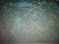
The map. Some of the white roads are actually drivable. Others are dog sled tracks.
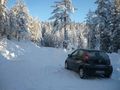
This one in particular is a dog sled track.
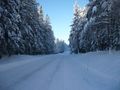
This is what a non-dog-sled-track looks like.
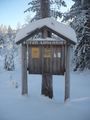
POSTED: Something about dogs.
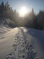
The track I trodded along.
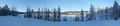
Another frozen lake.
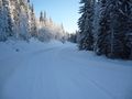
A road. This is getting too easy.
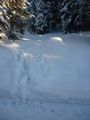
300m to go. Cross country ploughing-wise.
Elk tracks. Or something. I say it is elk.
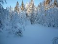
Winter wonderland dive-through.
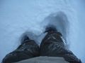
It's only knee-deep here. I can reach my camera.
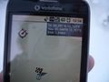
COORDINATES REACHED! WOO!
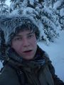
Exhausted relet
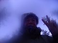
Ready for silliness. With some decent fog on the lens.
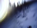
One of the two where the camera, while in the air, actually pointed roughly down. relet in the bottom right corner.
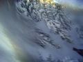
The other one.

Snow from below.
relet retrieving camera.
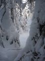
More winter wonderland.


