2010-02-07 49 -123
| Sun 7 Feb 2010 in 49,-123: 49.7696906, -123.1443701 geohashing.info google osm bing/os kml crox |
Location
Holy hash in Squamish. Anyone want to risk pre-Olympic mayhem to go?
- Holy hash indeed! The Olympic checkpoint doesn't come into effect until next week, but this is unaffected anyhow since it's south of it. Yangman 19:27, 5 February 2010 (UTC)
Participants
Actual
- Elbie & her hatscot
- Robyn & T-Rex
- user:thepiguy & Murray
- Mukmuk
Almost
- Flag Guy was unable to make it.
Plans
- 9:30 - Robyn picks others up at UBC -- corner of Marine Dr & Agronomy Rd
- 11:30 - arrive hashpoint?
- 13:30 - back in Vancouver?
Expedition
Road Trip
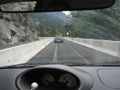
Bikes are allowed on the highway to Squamish, but it's a narrow, winding, treacherous highway, over seventy kilometres and mostly uphill. Not uphill as in hill, but uphill as in the name of the highway is "Sea-to-Sky" winding literally from sea level to the Olympic downhill skiing venue, on a wet February day. It requires concentration to drive it, and as cyclists we didn't want to put our lives in the hands of drivers who might not be concentrating.
Despite pre-Olympic chaos in Vancouver, this was one of the simplest expeditions Vancouver has ever seen. Robyn allowed 45 minutes to reach the appointed rendez-vous site at UBC, but required only half that on empty and unclosed roads. Apparently all the roads at UBC except the one she chose were closed, but thepiguy and Elbie also arrived early. The fourth intended participant called in sick, so the expedition departed Agronomy Road and Marine Drive, northeast bound on Marine, at 9:25 a.m. Navigation involved three left turns and one right turn for the entire trip, and by an extraordinary coincidence, left turns were permitted at all three planned points.
Robyn was driving, thepiguy was assigned navigation and environmental control duties, and Elbie in the back seat was given control over the stereo remote. Yeah, Robyn has a remote for her car stereo. It sounds like I have such a kickass car now. Such a good idea, but either the batteries were dead or it was the remote for a different stereo, so Elbie had to use voice commands instead.
The first potential issue was the Vancouver Olympic Lanes, special restricted lanes marked off with the diamond symbol used in Canada and the US for transit only, HOV only, bicycle only or other such restrictions. These ones don't have any instructions written on them, and last week many were ordinary transit/HOV lanes, but this week they are for vehicles on Olympic business only. Fortunately traffic was very light and the five rings were not a problem. Vancouverites are so terrorized by the prospect of the world arriving next week that we're afraid to move.
We reached highway 99 smoothly and followed it out of the city and through the suburb where Robyn used to live. Robyn gave the traditional recitation of how much the neighbourhood had changed in the intervening years, and Elbie and thepiguy endured it stoically, without even once saying, "You say this every time, Robyn." Robyn quickly became distracted by the changes to the highway. The road to the ferry terminal was smooth and construction-free for the first time in years, and then past the ferries as the major climb began, an extra lane appeared. It wasn't painted on, but instead straddled the centreline. It was marked off with semi-permanent pylons, too close together to change lanes. After some speculation as to what they were for or how they were to be used, we reached an opportunity to enter the middle lane. Robyn didn't react quickly enough to make the lane change, but driving in the outside lane became very irritating. There was a rumble strip on the shoulder: a line of very rough pavement designed to alert a careless driver that he or she was drifting off the road, but the way the forced lane divisions work, the choice was to straddle the rumble strip, with the right tires at the very edge of the pavement and the left at the right of the original lane, or to crowd over against the pylons with the left tires in the centre of what was once the lane, and the right tires just over the edge of road markings, just inside the rumble strip. Either way we were very glad we weren't trying to ride bikes on the shoulder at the same time as cars were being forced to drive on it.
We passed a number of police cars conspicuously stationed at side roads and pullouts. They weren't sufficiently concealed to serve as speed traps, so were probably enforcing the new law against driving while using handheld cellphones or other handheld distractions--including, geohashers should note, handheld GPS units. Always program your GPS while stationary, and if you don't have one that gives voice commands, appoint a non-driving navigator.
Our navigator had almost nothing to do, until we had reached Squamish and passed the downtown. We made the left on Depot Road and right on Ross, where we pulled up and parked mere metres from the hashpoint.
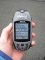
At the Geohash
Two GPS units quickly agreed on the spot, but Google Maps was in disagreement. Unless Google was revealing inside knowledge of a clandestine basement cult, there was no religious institution at or near the coordinates. The most institutional installment was the fire hydrant thepiguy used to support his camera tripod. We gathered, posed grinned and experienced a sort of anti-climactic "something is missing" feeling. In our province you follow roads for an hour and half, park, hike through brambles or up a mountain, and then reach the hashpoint. It was sort of unreal to drive up.
It was raining, so far too wet for chalk, so we constructed an xkcd marker out of some recently pruned evergreen boughs that were lying on the ground. It was one of those markers that you only know what it says if you already know what it says, but we do.
A dog bounded up to see us, but Robyn didn't know about the new hashdog ribbon, so didn't pat it in time before it bounded away. Next time we come up here it has to be with a full day to spend, so we can go hiking and sightseeing.
We explored the street a little, looking to see if the church was half a block away, but there weren't even any houses after half a block, just a narrowing road leading through trees, and a gate with a First Nations symbol on it, probably on a path down to the Squamish River.
Also, please note from the photographs that will be posted soon, the lush green surroundings and the few glimpses of snow at much higher elevations. This is the face of a Winter Olympic host city, the week before the games. The IOC came to check out the venue during a record-setting winter, then scheduled us to host the games during an El Niño year. Yeah, it's going to be a good one. I'm not joking when I say that they built the snowboarding venue out of straw and wood, then trucked in snow from a park about 400 km away to cover it up.
We adjourned to a nearby Tim Horton's for doughnuts. The window advertised the new "Canada doughnut" so we considered buying that, but it turned out to be an ordinary yeast-raised doughnut dipped in white icing and finished with red sprinkles. They may have been tiny maple leaf shaped sprinkles but they did not impress sufficiently to sway Robyn from her choice of Canadian Maple doughnut. That's like a Boston Cream, except dipped in maple instead of chocolate. Mmmm. Thepiguy bought and shared a box of Timbits and Elbie was sensible enough to have brought homemade hummus. She'll outlive us all.
As we were leaving, we saw a squad of police officers wearing bulletproof vests and getting into a minivan with Alberta plates. There were so many of them it produced a kind of reverse clown car effect. They're bringing in extra police from other provinces to police the games, and I guess the minivan is as good a vehicle as any.
On the Way Home
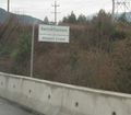
The road home was quicker; even in a car downhill goes by easier. We got some photos of the bilingual road signs. Not French-English as you might assume for the two founding nations of Canada, but Halkomelem: the language that was primarily spoken here just a hundred years ago, and the English: the primary language of the immigrants who have completely changed the character of the area since. Halkomelem orthography includes most of the Latin alphabet with diacriticals, apostrophes and sevens, so it's sort of like Klingon meets 1337. Note that the names on the signs are not translations of the English names, mostly bestowed around the time the highway was constructed, but the old names, the first names that humans ever gave those rivers.
As we descended the mountain, something odd appeared in the road surface. Train tracks. Not the kind where you cross the train tracks-- there's no way that could happen here, with the highway blasted out of and balanced on the side of a cliff, but a railroad line running along in the same direction as the road. The temporary widening of the highway into three lanes involved closing the parallel rail line and mostly paving over it. "This," said thepiguy as he photographed it, "is how Canadians do trains." He still misses the ease and ubiquity of rail travel in Europe.
Photos
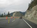
This is how we build highways in BC... with dynamite.
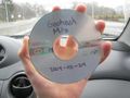
thepiguy was surprised to find the mix CD he prepared for this hash still playing in Robyn's car!
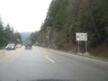
Trying out the mysterious middle lane of doom.
How do you pronounce "7" ?
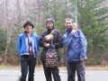
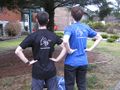
Geohashers in the rain!
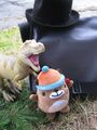
Hashcots in the rain!
W? What does that mean?
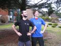
thepiguy and Robyn show of their Vancouver pride.
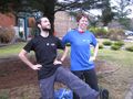
Left leg up?
Imported, of course!
Welcome to BC Rail!


