2010-02-15 45 -121
| Mon 15 Feb 2010 in 45,-121: 45.6243272, -121.1314454 geohashing.info google osm bing/os kml crox |
Location
Near the Columbia River in The Dales, Oregon
Participants
Plans
We're planning to head there on Monday...
Expedition
We set out from Hillsboro (with aperfectring driving for a change) around lunchtime, so we stopped at a little hole-in-the-wall, but very good Dim Sum place in Beaverton. There were a few leftovers, and the plan was to eat them at the hashpoint to count it as a Picnic. Then we continued on through Portland, being worried at the amount of traffic we saw. However, the traffic faded after we made it through the tunnel. As we continued east through Portland, we were treated with rare (for the winter) views of a very white and snow-covered Mt. Hood. Continuing through the Gorge, we enjoyed the scenery, particularly of the Columbia, and the less spectacular, but still breathtaking, views of Mount Hood.
As we neared The Dalles (and the hashpoint), Jim's GPS started to report that it was much closer than APR's navigation unit, so Jim started to tear things apart to see how he had mucked up the coordinates. But as we crossed over the Columbia and turned onto the road to the Dock (and the hashpoint), the GPS said it was only .1 miles, which was good, and about what we expected. As we passed by the nearest road point to the hashpoint, we noticed some very disappointing "No Trespassing" signs. They seemed to be spread out a bit, and it wasn't obvious why they were while driving.
We found a parking place at a nearby park, and began to walk back along the road to the hashpoint, noticing that, thankfully, the signs appeared to be on roads. This implied to us that you just weren't meant to drive in. Also, the best access path we found had no signs in sight. It was at this point, as we headed in, that we noticed that our GPS units were pointing up a 40ft (12m) cliff face. Luckily, it appeared there was a pseudo-path up along the side, but we couldn't tell if it would take us all the way up, like we needed. It was quite an upward trek to the hashpoint, with fairly steep dropoffs at a few points, but we made it to the hashpoint. There were a bunch of Canadians hanging around up there. (The honking kind, that is.... You know, with two legs.... and a couple of wings.... No, not like Robyn's wings... These have feathers....)
We took photos and carefully made our way back down the steep path to the car. Once we got back there, we noticed the leftovers sitting in the back seat. We missed getting the picnic hash! We packed up and started heading back to home. We decided that since we took the interstate on the way towards the hashpoint, that we would take the 2 lane state highway on the Washington side back home, and perhaps cross back at one of the few bridges when we got tired of the windyness. Unfortunately, when we decided that we wanted to switch back over, the only bridge before Vancouver (Washington) was a toll bridge. Since neither of us wanted to cough up the couple of dollars, we just dealt with the 20 miles or so of windyness until we got to Vancouver. We hit Portland around rush hour, but luckily since many people (including us) had the day off as a holiday, traffic wasn't too bad, for the most part. Another graticule visited by geohashers!
Live reports
- Success! Another graticule has been visited by two intrepid geohashers! -- aperfectring @45.6242,-121.1314 23:00, 15 February 2010 (UTC)
Achievements
Jim and APR earned the Land geohash achievement
|
Jim and APR earned the Graticule Unlocked Achievement
|
Photos
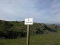
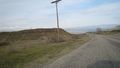
100 miles, and Jim and I see this... @45.6245,-121.1285
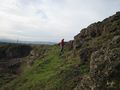
Jim ascending the cliff face on the way to the hashpoint
Canadians with wings (not Robyn)
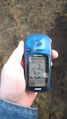
Proof!
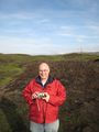
Jim at the hashpoint
The view down
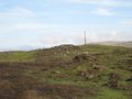
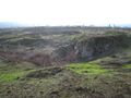
The view towards the park we parked at, the whole area looks like this. Yes, it *IS* awesome!
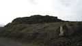
The view up
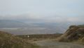
A view back, at what we climbed, as we headed back home.
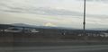
A beautiful enough day that you can see Mt. Hood from Portland, a rarity in the winter. Trust me, it looks a whole lot brighter when it practically fills your entire rear-view mirror.
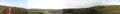
A panorama from the hashpoint.


