2010-02-27 45 -122
| Sat 27 Feb 2010 in 45,-122: 45.6032878, -122.7406376 geohashing.info google osm bing/os kml crox |
Contents
[hide]Location
On an service road in a North Portland rail yard.
Participants
Plans
I printed out the Peeron page. This proved to be an error, as it
- a) didn't have the pointer on it showing where the hashpoint was, which made it much less impressive to the railroad worker I showed it to and
- b) the coordinates weren't even readable on the page.
I remember to do Google Maps next time.
Expedition
Scooter needed to go and visit the vet, which was part of the way to the hashpoint, so we proceeded from there into Portland to visit the hashpoint. APR thought that the area wasn't going to be accessible, but I was thinking it might prove accessible, so I went.
Upon getting close to the hashpoint, I found nothing but trucking yards that were either closed, or didn't look open to the public. Finally, I located a railroad track running between two fenced areas that seemed to be open to travel. So, I parked the car, and left the hashcat to guard it and set off down the tracks. (Looking closely to figure out if an oncoming train would have to crush me.
The tracks were in disrepair, and when I got to the back of the fenced area, I found they were impassable by trains, so I was safe. I headed down a slope, and the hashpoint dropped to 120 feet away. But there was a huge mass of swarming raptors in front of me. There was a slightly cleared path, perhaps where a T.Rex came through and cleared some of them out, but it got pretty hairy after I got in a few feet, so I gave up with 80 feet to go. It also appeared to be an active section of a rail yard, so that didn't seem like the way to go.
I returned to the car, and tried to approach from several directions. Finally, I parked near a drive in and walked it to talk to some of the rail workers. Someone who was putting diesel into an engine directed me to an office, and someone there looked at my map and indicated that if I could take the access road I indicated as a way to end up at Columbia Boulevard and I might make it to the hashpoint, but I couldn't go into the rail yard.
So, I set off down the road, glancing at the GPS as it counted down. It hit 14 feet, which was below the error distance, so I took a quick picture of the area and nearby train (which didn't come out) and headed out. The pavement turned into gravel, so I ended up getting guided out by some other rail workers.
I headed home, but took the St. John's Bridge, and then Germantown Road, which had some very nice views of the area.
It was a nice adventure. I'm think the cat slept through much of it, and I doubt it really guarded the car. Since I brought the cat, I suspect it doesn't count as a Hashcat achievement. It might have counted as a Speed racer achievement, but I'm not sure there is a legal speed limit on an railroad service road.
Photos
The camera is having trouble and is producing pinko communist pictures. :-)
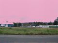
A view of the area
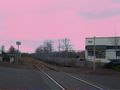
The rail line to the first attempt
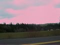
The view on the way home

The hashcat (who came along)


Jim earned the Land geohash achievement
|
Is it true that Jim earned the Hashcat achievement?
|