2010-04-25 45 -122
| Sun 25 Apr 2010 in 45,-122: 45.9440030, -122.0453958 geohashing.info google osm bing/os kml crox |
Location
In Gifford Pinchot National Forest along a National Forest road. Conditions unknown.
Participants
- APR - Going for the multihash! This is tenuous, it is a few miles up national forest roads, which tend to vary wildly in quality. We'll see how my trusty steed fares!
Plans
None
Expedition
It started off because I was pumped about the success earlier in the day. I decided I should try for a more challenging point. The roads up to the hashpoint seemed like they would be decent until at least a couple miles to the hashpoint. So I gathered my things and took off for the hashpoint.
As I got closer, the roads gradually got worse, until I was on a paved single-track with parts washed out. Then it degraded further to a well maintained gravel road. About a mile from the last turn I would need to make, and about 3.5 miles from the hashpoint, I saw a Subaru off to the side of the road, and snow covering the road further up. I drive up, see that the snowpack is only about 200ft long, and decide that I could most definitely walk/hike the 3.5 miles each way to the point. I then turn my car around, park it, and begin walking. The snowpack was maybe 4 inches thick, more than I would want to drive through in anything but a big 4WD truck given the slope (probably a good 10-15%).
I make it through the snowpack with minimal foot wetness, and proceed to hike up the mountain. I make it about 1 mile down the road (@ about 10% grade on average) when I see another snowpack. Figuring that it would remain about 4 inches deep for quite a while, I started in on it. About 300-400 ft in, the snow was now at least a foot deep, and my feet were quite wet and cold. I decided to give up and return down, tail between my legs. I trudge back down, taking some pictures of the scenery as I go. When I get back down, another car (audi wagon) has pulled up, and the drivers are inspecting the snow. They ask what the situation of the trail is, and I say that its clear for about a mile, but then the snow starts up again, and keeps going, and getting deeper. I also mention I only made it a few hundred feet after the next snowpack. A person from the Subaru was apparently in it when I walked by, but I hadn't seen them. She said that by the time she turned back (about 3 miles up the mountain, and still a good half mile from where I would need to stop), the snow was over 1.5 ft deep, maybe even 2 ft, and that it looked to keep getting deeper. Her friends continued on, though, but I suspect they were much better equipped for it than I was. This made me feel better about turning back, because there is no way I could climb another 2.5 miles @ 10% through that kind of snow. The guys from the Audi mention that they are thinking of trying to make it past this snowpack, and I advise against it, as it is probably deeper than they are thinking, and is rather steep.
After getting back into my car, I took my 2+ hour drive back along scenic roads. My feet were still wet (though no longer quite so cold) when I finally got back home.
Tracklog
Photos
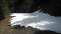
The first snowpack looking back towards the car.
Anti-proof

The look of failure (and also of a geohasher who didn't reach a hashpoint)
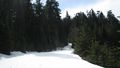
Failure snowpack one way
Then another
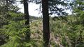
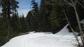
The look through the trees
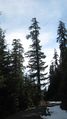
Tall trees
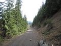
The way back, with some mountains and trees along the way
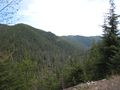
The landscape
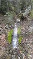
Pretty little waterfall.


