2010-06-13 49 -123
| Sun 13 Jun 2010 in 49,-123: 49.6961531, -123.1499792 geohashing.info google osm bing/os kml crox |
Location
Just south of Squamish, BC, off of Highway 99. It turned out to be a woodchip recycling facility (or something like that) on private property.
Participants
Planning
The hashpoint for this Sunday seemed to be nearly perfect at first glance. This was the second-last weekend before air384’s summer courses start up, and the day was supposed to be sunny and warm. The geohash looked like it would be just a quick drive up the Sea-to-Sky highway, a turnoff before Squamish, and then a picnic in the undoubtedly beautiful surrounding area. At worst, Google Maps showed it on what appeared to be a construction site. srs0 warned her that geohashes are never so easy, but she kept her fingers crossed anyway.
Since air384 and srs0 don’t own a vehicle with more than two wheels , they rented a Zipcar from a nearby location on UBC campus. (For anyone wondering more about Zipcar, air384 will happily rave about it to you.) Since the expedition was to be on a weekend day, they chose to rent a Prius, which is much cheaper to rent than a non-hybrid vehicle. The Prius wouldn’t be available till 11am, so that’s when they booked it.
Expedition
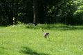
The morning of the expedition, air384 got up and baked brownies to commemorate the event. srs0 had already printed out the maps and the xkcd sign the night before; he also packed wraps and strawberries. air384 decided that the event was special enough to warrant opening the bottle of Schweppes Bitter Lemon srs0 had brought back from Germany for her. Besides which, it was expired. Running only slightly late by air384’s standards (and grossly late by srs0’s standards), they were out the door and on their way. As they approached the location of the car, they saw an endearing sight: a mother raccoon scaling a wall to get to her five raccoon pups, which were perched on the sloping roof of a townhouse. Instinctively, both air384 and srs0 stopped to take out their cameras, srs0 reaching for the new telephoto lens which he had yet to use. Unfortunately for the raccoon mom, there were three (human) children below the roof, pointing and shouting at her; she was obviously afraid and trying to protect the adorable baby raccoons. After a few more pictures, air384 and srs0 moved on, ardently wishing the kids would leave the raccoons alone.
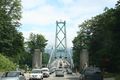
Finally, they made it to the car, and only 20 minutes late, at that. After a quick review of how to operate a hybrid (it has an on/off button!), they were off, with air384 driving and srs0 giving directions. Leaving Vancouver was pretty straightforward, thanks to Google Maps, but air384 was quickly reminded that Vancouver drivers were just that much more aggressive than she’s used to. The Prius steadily made it through the west end, across the Burrard Street Bridge, through downtown and Stanley Park, and across the Lion’s Gate Bridge.
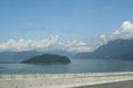
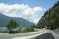
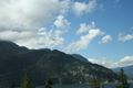
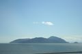
This is when the confusion between Highway 99 and Highway 1A began. Since the two overlap for a portion as one leaves Vancouver heading north, it can hard to tell whether one is going in the right direction at times. Thankfully, after some time there were signs indicating that this was the road for Squamish and Whistler, and air384 and srs0 relaxed a little bit. The sun came out, and the highway was high enough to afford a beautiful view of Howe Sound for those who did not have to keep their eyes trained on the road.
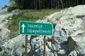
air384 had read the account of a previous geohash to Squamish (found here), so she knew to expect a narrow and twisty road. However, thanks to the $1.76 billion party that Vancouver recently threw, the road was pretty good – a four-lane highway divided by a concrete barrier, with bicycle lanes. During the drive, air384 and srs0 passed many small rivers which were noted by bilingual signs in both English and Halkomelem, the local language. srs0 took lots of pictures. The view continued to be beautiful, taunting air384 to look up from the constantly curving road.
The excitement built as they approached Squamish. The Google Maps directions instructed air384 to make a U-turn, but she decided to play it safe and turn off onto a side street instead. This decision proved fortuitous, as it happened to be the street leading to the beautiful new tourist information centre. Deciding that another map probably wasn’t a bad idea, air384 and srs0 headed in. They found not only an excellent free map of the town, but a great gift shop featuring a lot of local artists and artisans. They picked up a few postcards, a pair of oven mitts with First Nations art on them, and a tiny jade turtle for air384’s collection.
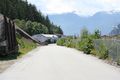
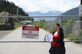
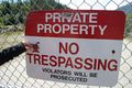
They headed back to the car, back down the road they came on, and easily found the turnoff required for the geohash. They saw a blue silo-type structure which they had previously found on Google Maps as a recognizable landmark (theirs was to be a no batteries hash). The excitement built even more... only to be met with a fence and a “No Trespassing” sign. Looking around, air384 and srs0 realized that this was it. What had looked like a construction site from the satellite view on Google Maps was in fact some sort of woodchip recycling plant, and was surrounded by a chain link fence topped with barbed wire. air384’s first geohash would have to be a consolation prize after all.
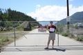
Not to have come this far for nothing, air384 and srs0 documented the location nonetheless with numerous photos. As you can see below, they both posed with a printed off xkcd sign, and air384’s hashscot, the Red Rabbit, posed too. They also picked up some geotrash, promptly using hand sanitizer after the photos were taken. They had initially intended to picnic at the site, but it was very windy and lacked the ambiance of a typical picnic spot, so they decided to consult their free map for a more suitable location.
The map revealed that the area near the tourist info centre was a small park with some picnic benches, so air384 and srs0 decided to eat there, first stopping to buy stamps. Since the most logical place to buy stamps that they had seen on their way out was the 7-11 just past the tourist info centre, they headed there, picking up two much needed GeoSquishies. Unbeknownst to them, they unfortunately did not qualify for the GeoSquishy award since they did not actually make it to the hashpoint. The squishies were pretty tasty anyway. Oddly enough, the 7-11 did not sell stamps, so they headed to a post office which was not much further away. They bought very pretty stamps and settled in the car to write two postcards – they wrote one to thepiguy, and air384 also decided to write one to her parents. The postcards were mailed at the same post office, and the two finally headed for the picnic area, the effects of low blood sugar now evident in air384’s (lack of) direction-taking skills.
The picnic spot was a picnic bench overlooking what would’ve been a small river, had it not dried up. There were lots of birds and rock climbers to watch on the nearby Strawmus Chief. There were wraps, strawberries, and brownies to consume, and indubitably delicious Bitter Lemon to wash everything down. There were no typical picnic accoutrements because air384 and srs0 regrettably don’t own any, though their plastic containers were pretty colourful anyway. After a few more photos with the new lens, they headed back to the car for the drive back.
The drive back was, for the most part, like the drive there but mostly downhill. The roads were still twisty and the drivers were still going way too fast and the view was still gorgeous but unsafe for the driver to look at. Unfortunately, the signage entering Vancouver was just as confusing as it was when exiting, and both air384 and srs0 somehow missed the turnoff for the Lion’s Gate Bridge. The Ironworkers Memorial Bridge would be their only other option, and somehow they not only managed to take the wrong turnoff for it, but also take the wrong street once they crossed it. Finally, they were back on a road which they both knew, headed in the right direction. They inched across Vancouver in the Sunday afternoon traffic and at long last made it back to the parking lot where the car was due. They grabbed all their stuff, locked the car, and decided to walk home since it was such a nice day. For a first geohash, not too bad, though air384 is looking forward to her first success.
Images
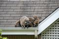
Raccoons were encountered.
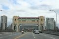
Bridges were crossed.
Bridges were crossed (part two).
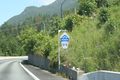
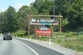
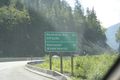
Squamish signs!
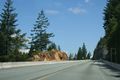
A view from the road.
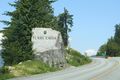
The sign depicting our road name.
Another view from the road.
Yet another view from the road.
An interesting village name.
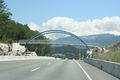
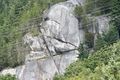
A cool bridge near Squamish.
Squamish!
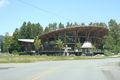
Squamish visitor center, view 1.
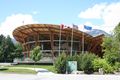
Squamish visitor center, view 2.
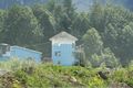
A visible landmark. Getting close!
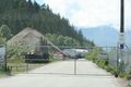
A gate approaches...
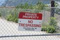
No trespassing!
The view beyond the gate.
air384 at the gate.
srs0 at the gate.
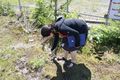
Geotrash part 1.
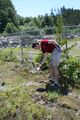
Geotrash part 2.
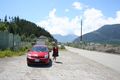
The car by the gate.
air384's hashscot at the gate.

A panorama by the gate.

Geosquishies!
Stamps...
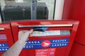
...and postcards!
A bird taking flight.
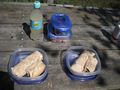
Picnic time.
Rock climbing in progress...

Eagles in the sky.
A view on the way home.
Vancouver's name in another language.
Another view on the way home.


Achievements
air384 and srs0 earned the No trespassing consolation prize
|
air384 and srs0 earned the Picnic achievement
|
air384 earned the GeoTrash Geohash Achievement
|
srs0 earned the GeoTrash Geohash Achievement
|