2010-06-19 -36 174
| Sat 19 Jun 2010 in -36,174: -36.9666160, 174.6055144 geohashing.info google osm bing/os kml crox |
Location
A spot of bush next to one of our cities water reservoirs out in Parau, West Auckland.
Participants
- JimmyNZ
- Greenslime - in spirit
Plans
Well Greenslime is away this weekend, but i know I'd get stick from her if she found out there was a hash in our backyard and I didn't give it a good go. So, the aim is to procure a GPS, hopefully off a chap I'm going to be nicking a hedge trimmer from this morning. Once I've done the well-needed garden work, jump in my trusty bluebird with a camera, said mentioned GPS and drive as close to the hash as possible. Then I'll be use what looks to be a well placed track to get as close to the point as possible, then i'll bush bash through some lovely native forest the rest of the way. I should either accomplish this or get lost on the way. Either or, best of luck!
Expedition
So, finish my yard work, jump in the car, navigate a 40 minute drive across windy west Auckland roads and arrive at the base of Lower Nihotupu Reservoir Dam. Park the car up and head up a little gravel service road. Round a corner and find signs saying 'Water Supply Catchment. Do not enter.'
Ok, well it looks like my primary, quick enter and exit way is blocked. In the background the dam caretaker (whose house is behind me) dogs start yapping and making an increasingly loud amount of noise. Best leg it and not try pushing my luck here.
Head back down to the car and look for some sort of plan B as I still do not believe I’m beat, I’m so close, only 300m or so away. Decide I can leg it up Panto Track, a little further away until I am at right angles to the hash, put a waypoint on the GPS (so I know my exit from track path) and try bashing straight down from there. Should be easy, right?
Head up Panto Track, turns out to be a real quagmire of slippery clay. I plod my way up this until I think I’m at right angles. Mark a point on my GPS, veer right and start bashing. This starts out pretty easy and soon I stumble onto a little quad bike track that the ranger guys must use. Taking advantage of this I follow it for a bit then deem that I must again bash through some more bush. So take a point on the GPS, veer right and start bashing...again.
This time, I’m faced with a downhill slope in a little rain, with slippery ground and medium dense foliage. I have no issues with this, though it soon becomes thicker with gorse (not my most favorite bush) and worse still the evil New Zealand cutty grass (yes, my least favourite kind of fudging grass). Soon I look down to see my once beautiful (and handsome) knees are a gash with blood. Stupid me. So I continue for a little, not really making progress, and it starts to get more wet, and darker. Knowing that it’s not really a safe piece of bush to get lost in, even though I can't get lost since I'm technically walking downhill towards a big freaking water reservoir, I begrudgingly call it quits.
Sorry Greenslime :( Hope the fact I bled over this one shows how much I tried.
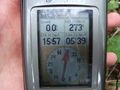
So I take the necessary photos (yes ignore the fact the photo says Hash 16 June something, i reused a waypoint from last time i pinched my friends GPS), retrace my steps and bash out. No geohash achieved, but I still came pretty dam(n) close, okay so maybe with 273m of the point. Again, damnit.
Photos
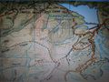
Nothing says prepared like a camera photo of a map being displayed from a laptop
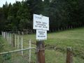
First way i went there were signs saying no.

Plan B was to try the Parau Track
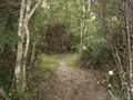
Of course this track was a quagmire!
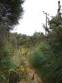
Bush bashing finds me a nice quadbike track
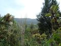
The hash is between me and that nice blue lake, somewhere

A little soggy,muddy and bleeding Jimmynz
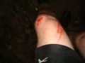
Departing gift from the NZ bush

Not far to go, but not possible to go
So close yet so far.
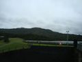
View from other side of lake across to hash. Caretakers hut is just in the left of the shot


Hash Awards
JimmyNZ earned the Done with Nature consolation prize
|
JimmyNZ earned the Trail of blood consolation prize
|