2010-06-27 48 9
| Sun 27 Jun 2010 in 48,9: 48.1820999, 9.3370455 geohashing.info google osm bing/os kml crox |
Location
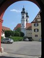
In a remote forest in the Schwäbische Alb mountains, municipality of Langenenslingen.
Participants
Expedition
After the two consecutives of Friday and saturday, and with the knowledge that monday's hash would be rather close and probably reachable, the idea to upgrade my old 3-consecutive to a 4-consecutive sounded quite attractive. Also, this hash was in a part of the Alb where I never had been before, and I could easily include a valley into the trip which has been recommended to me as exceptionally beautiful before. Also, the fact that the german soccer team would engage in senseless ball-beating somewhere in the southern hemisphere during the afternoon promised conveniently empty roads.
On sundays during the summer half of the year there is this special network of trains and buses which also carry bikes for free on the Alb. I chose the 9:29 train to Kleinengstingen, getting off at the sleeping village of Gauselfingen, to continue by bike.
Already at the next village I got stopped. The trails into the village had been closed even for pedestrians, so it took some ridiculous rerouting to get into the village centre where I found the reasons: One, road construction, Two, A local running, walking and mountainbiking event which was about to start around noon.
- Ok, guys, what else is closed? Where's the racing route?
- Well, the bikers go this way *point*, the runners down the Fehla valley
- Uh. That's where I wanted to go.
- Shouldn't be a problem. Are you going to start now?
- Yes, about so... thought of maybe visiting that castle ruins along the way...
- The main field doesn't start before twelve.
- Ok... I'll see that I'm at Hettingen by twelve then, and out of your way. Thanks.
So I dropped visiting the castle and went straight through the valley which really was nice and worth a visit, but not that exceptional - there are more of these really beautiful valleys around, only most are probably less known for being more remote.
At Hettingen I left the common routes and soon was all alone in a rural wide landscape of rolling hills, trying to find my way with a twenty year old and not very precise map. OSM was basically restricted to the main roads in this area, so it was quite a conflict: Should I rather take the roads (which had very low traffic anyway) or choose tracks to improve OSM?
At some time I had reached Ittenhausen, last village before the hash. The map showed a chapel into the direction of the hash which I had seen mentioned in a few tourist guides so I thought to visit that - however, some misleading signage made me realize too late that I had taken a wrong road which didn't lead there, but instead almost straight into the direction of the hash. Whatever.
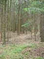
Only almost straight, anyway. Acceptable forest tracks led me closer, bad forest tracks even closer, then there was only grass left. Knee deep grass on what probably was meant to be a forest track long time ago, but at least the ground was not muddy after a few warm and dry days. And finally the forest made way for a large clearing, where the grass was mown, and moving was easy (and free of ticks) again.
The hash itself was about 50 m off the clearing into a light forest. Nothing special but who would have expected that?
The grass on the clearing was mown. So, someone had reached this clearing with a tractor at some time. And he hadn't come the way I had come, that was for sure. Which means, there must be another way into the clearing, probably at the other end, so I tried to find that one. There was, and it was a decent gravel track which soon led me out of the forest.
Basically there was a number of choices to get home now. I didn't want to get back home too late, and I didn't want to make this an exhausting long trip since it was very hot, and the next day would bring another bike hash. Which was why I dropped the idea to go back home all the way. I also dropped it for being boring, anyway, and instead decided to go for the Donau valley and Zwiefalten, trying to catch the bike bus to Münsingen there. The bad thing about that was that the last bus went at 16:45 - ridiculously early to return from a sunday trip.
Around 15:30, I came by a sign that showed Zwiefalten 7 km and followed that road, well confident that I was good in time to catch that bus.
Two kilometers further, there even was a sign for a bike trail to Zwiefalten. It showed that it was only 7 km to go, and I followed it.
Shortly later but significantly lower in the valley, there was the next one, pointing up to where I had come from and claiming it would be just 7 more kilometers from here. I ignored it, and decided to stay in the valley instead, taking the beaten Donau valley trail instead.
After another five kilometers, another sign told me that the distance to Zwiefalten had apparently dropped to only 7 kilometers from there.
When I finally reached Zwiefalten, it was about 16:15. Plenty of time to find the bus stop and take a short look at the famous monastery (which now mostly is a psychiatric clinic), and get into a discussion with the bus driver because he was unable to sell me a ticket valid on that line but instead wanted to sell me one which was not valid here and would be more expensive.
Gallery
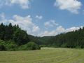
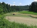
Landscape impressions along the way
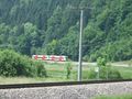
The train which brought me to Gauselfingen - met it again later
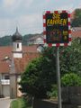
Friendly speed trap
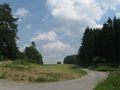
Further up...
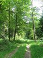
It's still a way
Not so much any more
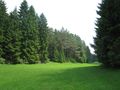
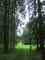
From this clearing...
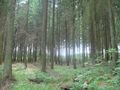
... 50 m into this forest.
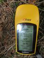
Coordinates reached
The hashpoint
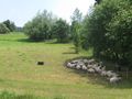
There surely isn't enough shadow on this paddock
End of bike trip: Zwiefalten
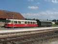
Weird train incoming. This is a semi-regular train composed of a 1960 railcar and a pre-WW2 coach.
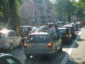
Soccer fans blocking the main road at Reutlingen (bus lane was kept free)


Consecutive Geohash
This hash was the third of a series of 7 consecutive geohashes:
- 2010-06-25 48 9 - Reutlingen-Mittelstadt, by bike
- 2010-06-26 48 9 - Riederich, midnight hash by bike
- 2010-06-27 48 9 - Langenenslingen, by train, bus and bike
- 2010-06-28 48 8 - Rottenburg-Ergenzingen, by bike
- 2010-06-29 48 8 - Balingen-Endingen, by train and bus
- 2010-06-30 47 9 - Sauldorf, by train, bus and hiking
- 2010-07-01 48 8 - Deißlingen-Lauffen, by train, bus and hiking - No trespassing
Ekorren earned the Consecutive geohash achievement
|