2010-06-29 48 8
| Tue 29 Jun 2010 in 48,8: 48.2566379, 8.8403584 geohashing.info google osm bing/os kml crox |
Contents
[hide]Location
At Balingen-Endingen, at the side of the B27 primary road, just a few metres behind bus stop "Krone" (=crown)
Participants
Expedition
After already four consecutives, this really easy one was a hash I couldn't miss. Also, it was a little bit special for me since the hash was located on federal highway B27 - which is just the same highway which runs along the quarter I live in. Just about 40 km further.
After several bike trips the days before, and wanting to be prepared for another consecutive if available (and not too hard), I didn't want to do this by bike. However, there was supposed to be a bus stop just at the hash, and bus line 7440 would go at least once per hour, usually more frequent. Trains to Balingen also go three times in two hours, so I didn't think it would actually be necessary to check for a timetable beforehand, and neither hurried up too much. When I felt ready to go, I had missed the 13:03 train, and just managed to catch the 13:31 from Derendingen. Only to find that I really should have taken the 13:03, because when I arrived at Balingen shortly past 14:00, the next bus to Endingen wasn't due before 15:00. I shortly considered walking but then decided that if a hash actually falls on a road a bus takes, almost exactly at the bus stop, it would be bad style not to go by bus.
So I took a short stroll into town and bought some supplies, then got on the bus, got off at the hash stop and had reached the hash within of half a minute. Couldn't be much easier, could it? A few photos, done. Well, and missed a bus again. Walk back? Na. Stroll through the village and map a few more roads for OSM? Better. Killed a bit of time that way, and took a bus back to Balingen.
Now, the day wasn't quite over, and there is actually a bit to see around, so I consulted the timetable and found that there still was a bus up to the Lochen pass, 886 m above sea level and about 400 m above where I was. Arriving there early enough to allow for a little hike along the cliffs and still get back home the same evening. So this is what I did, those pictures below should be enough of a report ;)
Gallery
With a proper map, nothing can go wrong.
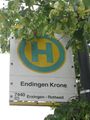
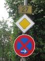
Get off here
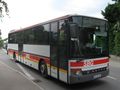
Bus just about to hit the hashpoint
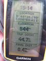
Coordinates reached
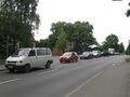
Congestion at the hashpoint. The white car in front occupies the exact spot.
By car, I could have just followed federal highway 27 - I'm living just about 500m off that road.
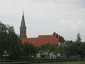
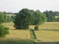
Small impression of hash village
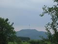
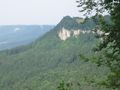
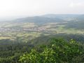
Plettenberg from a distance
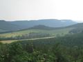
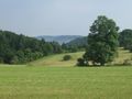
Landscape impression up in the mountains
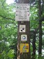
All ways lead to the Hörnle? At least five marked trails come along here.
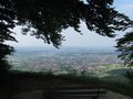
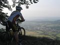
View from the Schinderlucke cliff
Three views on the road that took me up
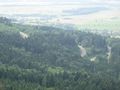
View on the Hörnle cliff
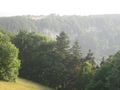
More landscape impressions to the hilly side
View from the Hörnle cliff
Other visitors. That's not me ;)
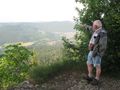
Neither that. This guy was 80 years old and still went hiking regularily
View to the Schinderlucke cliff


Achievements
This hash was the fifth of a series of 7 consecutive geohashes:
- 2010-06-25 48 9 - Reutlingen-Mittelstadt, by bike
- 2010-06-26 48 9 - Riederich, midnight hash by bike
- 2010-06-27 48 9 - Langenenslingen, by train, bus and bike
- 2010-06-28 48 8 - Rottenburg-Ergenzingen, by bike
- 2010-06-29 48 8 - Balingen-Endingen, by train and bus
- 2010-06-30 47 9 - Sauldorf, by train, bus and hiking
- 2010-07-01 48 8 - Deißlingen-Lauffen, by train, bus and hiking - No trespassing
Ekorren earned the Consecutive geohash achievement
|
Also it was a Déjà vu geohash. Bus line 7440 runs through the hash on the way from Balingen to Rottweil. Some years ago, for several years, I had monthly passes which were also valid here, and I did use them. I believe if I look hard enough, I'll be able to prove that I have taken that bus before, but for now I just hope you'll believe me.
Ekorren earned the Déjà Vu Geohash Achievement
|