2010-08-12 49 -123
| Thu 12 Aug 2010 in 49,-123: 49.2326602, -123.2127346 geohashing.info google osm bing/os kml crox |
Contents
[hide]Location
South of Wreck Beach, east of the nearby country club.
Participants
Planning
srs0 is hoping to be there around 18:15. He's thinking of biking to here[1] and then finding a path down to the beach and walking. Does anyone know if the above location has a path down to the beach or if he will have to go down by the path he knows about at 16th and Marine Drive instead? -Srs0 15:34, 12 August 2010 (UTC)
I know a path on the Reserve that should get us a bit closer. I, however, can't do 18:15. Aiming to be there for noonish. - Elbie 17:04, 12 August 2010 (UTC)
I'm back. Success! You can't access it from the east, though - no trespassing from the country club. I went around it and came up from the south: this involved slightly over a kilometre of weed-wacking. Wouldn't recommend it as a means of getting there (from the north looks more promising -- kayak hash would be even better). Either way, bring good rain boots, it's mucky. - Elbie 19:41, 12 August 2010 (UTC)
Thanks for the heads up - I was going to walk along the beach barefoot. I'll bring the hiking boots instead. Anyone else planning on heading there later tonight? -Srs0 19:48, 12 August 2010 (UTC)
- Also-- bring a good hat. I had a sad lack of tree cover on my trek out there! Good luck! - Elbie 19:54, 12 August 2010 (UTC)
- Shall do, thanks. Also, for anyone who was planning on going tonight, I'm now aiming for closer to 17:30 or 17:45. I doubt there's anyone, but just in case. -Srs0 23:04, 12 August 2010 (UTC)
- Then to warn you if you didn't look it up already -- high tide's at 8:37PM. - Elbie
Expedition
Elbie
Forthcoming.
srs0
I couldn't bring myself to write this immediately after the expedition due to how brutal it was. I've already become a geohashualty once on the way back from a hashpoint, and I came close to doing so a second time in this expedition. However, it was also a great expedition, and I got to try out my new (at the time) telephoto lens on the nearby herons. Needless to say, this geohash had its ups and downs, both figuratively and literally.
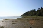
I began by biking to the lookout point overlooking southern Wreck Beach, a bit north of the geohash. I locked my bike to the sign warning of cliffs (make note of this for later), and started off down the path, not sure if there was even a way to get to the beach. Sure enough, there was, but the way was very steep. After a bit, the path went back upwards, but I wanted to go down to the beach, so I left the trail.
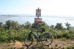
What's this foreboding feeling I have about the sign?
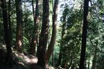
Yay for paths!

Time to leave the path.


Eventually, I managed to reach ocean level, to be met with a sea of five to six feet high Typha rather than water. While making my way through all the plants, I received a glancing blow from a raptor, that I thought I might as well take a picture of. However, it serves a good reference photo for later. After a while of heading west, I managed to reach the water.
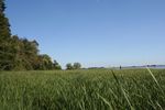
Typha Troubles.
The scouting raptor.
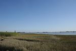
The ocean!


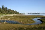
Upon reaching the water, I turned south and headed towards the geohash. It was slow going, due to the wet sand/mud on the beach. (I decided to walk on the mud instead of the edge of the plants to try to minimize the damage I was doing to the local environment.) The way was criss-crossed with small streams, which served for a beautiful hike. Eventually, I reached the general hash area. I don't have a GPS, so I determined this by watching for the respective thinning in the trees that google maps appeared to show by the golf course, which was near the hashpoint. I then walked around in the Typha for a while, in order to hopefully cross the actual hashpoint. I then declared it "good enough", and turned around to head back home. I had left my bike behind approximately half an hour ago.
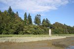
Leaving a trail.
A little stream.

The source of the little stream.
The general hashpoint vacinity is over there.


Shortly after turning around, I saw a pair of herons. I took many, many pictures, the best of which can be seen below.
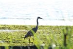
A standing heron.
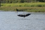
A landing heron.
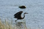
A heron about to take off.
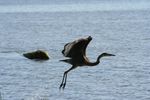
A heron that just took off.
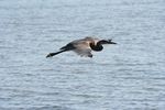
A flying heron.

A flapping heron.

A gliding heron.


Now begins the brutal part of the expedition. I don't have any pictures of it, because I didn't really have a free hand at any point. I wish that I took a picture before hand, but I didn't foresee the troubles that would follow...
I reached the bottom of the cliff where my bike was (or so I estimated, it turns out correctly) and realized that I wasn't sure what to do. I couldn't follow the path back up, as I didn't take a path down. I could go onwards, but that was a couple km to the main Wreck Beach area, and the tide was coming in very fast. I could go back a bit and try to find the path up, but I wasn't sure where it was. As such, I (stupidly) decided to just try my luck with where I was. Yes, I decided to scale the cliff that the sign my bike was locked to was warning about.
Now, some additional details. This cliff was covered in what I thought were bushes. Upon closer inspection, they were covered in loads of thorns. I put on my biking gloves, found a sturdy stick at the bottom of the slope, and used it to bash the thorny vines out of my way. After around 50m, I even had to pull out my pocket knife (which I thankfully had on me) to cut some of the vines, as they were so thick going up the slope that I literally could not pass otherwise. I feel really bad about it, as I undoubtedly hurt the plants, but at this point I was terrified of severely hurting myself. At points I was clinging to the cliff and had to half-jump and grab onto a higher rock/soil ledge to make progress (all the while through thorn bushes). This slope was at least an 80 degree incline, if not more, half of the time. The last 20 or so meters was the worst, because the top of the cliff (as you can see in the first picture) is one big thorny mess, and to top that off the incline was completely vertical. Thankfully I had some rock climbing experience in the past, but it was still an experience that I do not wish to ever repeat.
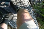
Thankfully, as you can guess by the fact that I'm writing this, I made it up in one piece. The trek that took me 25 minutes of walking to reach from my bike ended up taking an hour and ten minutes on the way back. On reaching the top, I took a quick picture of the ocean from the top of the cliff, and then collapsed for a few minutes, before getting on my bike and slowly heading home. Upon arriving back home, I took a picture of one of my hands and one of my legs to show the results. The majority of the cuts didn't show up, as there were lots scratches that just turned into pink marks. Now that was a raptor attack...
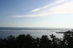
I made it!
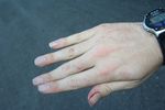
The post-raptor attack hand.

The post-raptor attack leg.


Looking back, it was a good expedition, but I don't know what part of me though it was a good idea to scale the cliff on the way back. That was definitely not a smart idea, and one which I still regret. I'm just glad that I didn't fall at any point on the climb, as it could have been fatal. Thankfully, I only received superficial wounds, and I was fine around a week later.