2010-10-02 52 0
| Sat 2 Oct 2010 in Cambridge: 52.3421267, 0.2375500 geohashing.info google osm bing/os kml crox |
Contents
[hide]Location
On a public footpath east of Stretham, near Ely. There's also a geocache very close -- listed as "0.01 km" away.
Participants
Expeditions
It wasn't possible to get to this one at the canonical 4pm meetup time, as I was still on my way home from a maths tutorial at that point. However, after a cup of tea and a bit of a sit-down (it'd been a long day; I was at work at 6:15am and went straight to my maths session at 10:45) I decided to set out hashing before it got dark.
Like yesterday, this was close-ish to home (14.5km) but I was too knackered to cycle, so went by car. I drove up the A10 from Cambridge to Stretham, then turned right onto a minor road and found a lay-by to park in when I got close to the point where the footpath crossed the road, right next to a bridge over the River Great Ouse. This is pronounced "ooze" and it's basically a big drainage ditch for quite a lot of the flat plain that is eastern England.
I said hello to some geocows that were in a field on the other side of the road. They thought I was vaguely interesting and made cow noises at me. Then I set off along the footpath, which was on a raised bank by the side of the river -- perhaps so that it would still be passable in case of flooding (and would help save the surrounding fields, too). I walked along the path for about 500 meters, and found that I needed merely to step sideways down the bank a meter or two to find the geohash.
After that I turned my attention to the geocache I knew was hidden mere metres away from the hashpoint. At this point I realised I'd left the bit of paper with the coordinates written on it in the car. However, with a little guesswork and a bit of luck the cache was found anyway -- it was a 2ml sample tube poked into a hole in the side of a fencepost. I signed the log and tried to photograph it. The camera batteries were dead.
Happily, I'd brought some spares. Unhappily, they were good enough for the GPS but not high-power enough for the camera, which refused even to switch on (it has a particularly petulant way of flashing a small red light at you when it can't be bothered to do this). Happily again, though, my backup plan worked -- I took the batteries out of the camera, warmed them up by sticking up my jumper for a few minutes, and then tried again. Photos of the geohash from the geocache, and vice versa, were taken. The GPS, at three-meter accuracy, claimed a distance of 10.9 meters from the one to the other.
As the camera batteries then finally expired for good (or at least until I recharge them), I wandered back along the path. A heron flapped lazily away from me in the gathering gloom. Had it not been raining gently, this would have been a lovely evening, but as it was, it was still a lucky location and I enjoyed my trip.
Photos
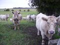
Friendly geocows.
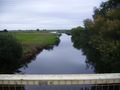
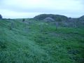
The River Great Ouse, beside which I walked.
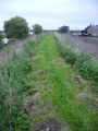
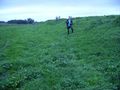
The path along which I walked.
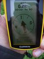
The coordinates towards which I walked.
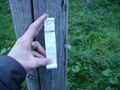
The cache I found ten metres away ...
... hidden in the side of a post.
Looking from cache to hash.


Achievements
Benjw earned the Land geohash achievement
|
Benjw earned the Hash collision achievement
|
Benjw earned the Consecutive geohash achievement
|