2010-12-07 45 -122
| Tue 7 Dec 2010 in 45,-122: 45.5089076, -122.7234140 geohashing.info google osm bing/os kml crox |
Location
Near the Zoo, between SW Canyon Court and Hwy 26. Appears to be on the SW Canyon Court side of any barriers.
Today's battleship location is: C 6
Participants
Plans
I'll get done with work a little after 5, will bring my geohashing stuffs with me, and will drive to work. That should put me to the hashpoint between 5:30 and 6PM. It should take me 20-30 minutes to get out to the hashpoint from when I leave. --aperfectring 15:17, 7 December 2010 (UTC)
Folks will be shocked to learn this hashpoint is close to me, too, so I'm also tempted to make a try for it. No Timing yet, though. Jiml 17:57, 7 December 2010 (UTC)
Expedition
APR got done with work about 5:15, and headed over to Jim's office to pick him up. After Jim came down, APR started driving them to the hashpoint. They decided to take 26, because there is not really a good way to the hashpoint otherwise. They realized the potential risk, and decided the chances of a backup was low. About 45 minutes later, after averaging about 15 mph the whole trip, they finally made it to their exit on 26, and found a place to park relatively near the hashpoint. The walked up the street to it, took some pictures, and made their way back. On the way back, they decided that it would be best to take surface streets, because the highway was clogged in both directions when they were coming to the hashpoint. APR then dropped Jim off at his office, and made his way home.
Tracklog
Photos
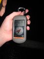
APR's GPS proof
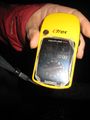
Jim's GPS proof

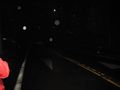
Jim at the hashpoint
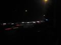
Traffic on the highway

Eastbound on Canyon Court
Westbound on Canyon Court


