2011-02-20 52 -0

| This expedition was part of a multihash by Benjw. For the other parts, see: | |||||
|---|---|---|---|---|---|
| 2011-02-20 52 0 | 2011-02-20 52 -0 | ||||
| Sun 20 Feb 2011 in Northampton: 52.0552236, -0.2204629 geohashing.info google osm bing/os kml crox |
Contents
[hide]Location
The corner of a field between Hinxworth, Hertfordshire, and Biggleswade, Bedfordshire, mere metres off a public footpath, and less than a mile from the Herts-Beds border.
Participants
The expedition
Having arranged to meet Sourcerer at the Cambridge hashpoint early on a Sunday morning, Ben saw that the Northampton hashpoint was just as accessible and not too far away. Taking advantage of the lack of traffic at 8am on Sunday, therefore, he enjoyed a gentle drive between the two after Sourcerer left to catch his plane.
The hashpoint was under some trees in a field through which ran a public footpath, so the only difficult thing about it would be finding somewhere to park the car. As it turned out, the verge by the start of the footpath was wide enough, so Ben went through the kissing-gate into the field, and followed the GPS arrow to the hashpoint, which was by a fallen tree. The grass was very wet from this morning's mist, so even that short walk was enough to get wet socks. A few quick photos were taken, and Ben returned home, having enjoyed an early morning out and about when more sensible people non-geohashers were still tucked up in bed.
Photographic documentation
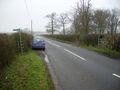
No cars came past while I was here, anyway
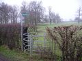
The kissing-gate into the field
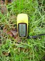
Proof of hash
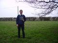
One happy hasher
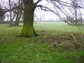
Looking out over the field from under the trees
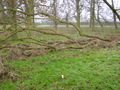
A fallen tree next to the hashpoint


Shiny ribbons earned
Benjw earned the Land geohash achievement
|
Benjw earned the Multihash Achievement
|