2011-02-27 48 13
| Sun 27 Feb 2011 in Passau, Germany: 48.9414751, 13.1634574 geohashing.info google osm bing/os kml crox |

In a forest, about 4km southeast of Regen, close to Weißenstein with its nice castle ruin.
Participants
- dawidi from Regensburg
- Tanya and family from Regensburg
- Thomcat, temporarily staying in München
- Zb and drag-along Mar from München
Expedition
Thomcat, Mar and Zb met at the platform in München Hbf and took a train to Plattling. There even was a bit of sun between Freising and Landshut. They weren't able to take the sunshine with them, however, and had to cope with cloudy weather for the rest of the day.
When they got off in Plattling, dawidi and Tanya with her family (who had taken another train from Regensburg-Prüfening) were already waiting at the platform and greeted them.
They boarded another train that took them along the most beautiful route to Regen.
From the station in Regen, they went steeply uphill towards a 900 year old castle ruin in Weißenstein. The castle's tower is closed to visitors over the winter, but it probably wasn't too much of a loss - the low clouds limited visibility to maybe two kilometers anyway. Instead, they inspected the medieval furnitorture devices on display inside the castle and the "danger of collapse" warning signs. Next to the castle, a little "forest of glass" art installation (more like a park than a forest) reminded them that the region they were in used to be big in glass manufacturing.
Continuing towards the hash, they walked along a stretch of the Pfahl, an outcrop of quartz rock forming a straight line of 150km through the Bavarian Forest, with the castle in Weißenstein being built at the outcrop's point of maximum elevation. Besides the rocks, a peculiar density of rather new-looking bat boxes mounted on trees caught their attention... and then, just a bit south of the outcrop, it was time for the GPS dance.
Having decided not to spend four, but just three hours for the walking part of the trip - so as to get back to the station in daylight, and back home before 20:00 - they didn't stand around at the hash for much longer after taking a couple of pictures, but started walking back at a slightly accelerated pace. Since we took exactly the same (shortest) way back to the station, not much worth noting happened during that time, except that our youngest participant still didn't show any sign of getting tired after walking about 10 kilometers... :-)
During the train ride through the forest, back down into the Donau valley, dawidi videoed out the back of the train, and produced a little video of the ride.
In Plattling, they split up rather abruptly, as the Munich group had to run to catch their connection. The Regensburg group's train left not too long afterwards, but was held up for a while about 10km outside Regensburg before getting them home.
Gallery
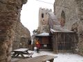
Inside the castle.
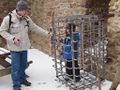
Hey! Let me out!
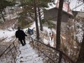
Leaving the castle.
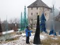
A "forest of glass" in Weißenstein.
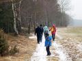
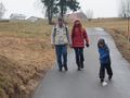
Walking towards the hash.

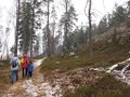
Coordinates reached.


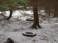
Thomcat discovered a couple of truck tires near the hash.
Walking back along the "Pfahl" outcrop.
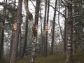
Bat hotels.

Back to Weißenstein.


Tired? Me? No.

Thomcat overlooking the town, waiting for the others.

