2011-07-03 52 0
| Sun 3 Jul 2011 in Cambridge: 52.1440572, 0.5689717 geohashing.info google osm bing/os kml crox |
Contents
[hide]Location
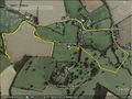
1) In the grounds of Denston Hall 15 km south west of Bury St Edmunds, Suffolk, UK, logged at wikiloc.
2011-07-03 52 0 :: 2011-07-03 52 1
Participants
Expedition
This was a clumsy but successful expedition with two quite significant navigation errors and one semi-deliberate mistake. The public footpath had been diverted to avoid the field with the hashpoint. Where the two fields joined, there was no gate or fence or signpost so I rejoined the track of the original path as it was before the diversion. There really was no way of knowing which field the diverted path was in. The hashpoint was a few paces off this "path". Later I discovered I had followed the wrong route but I did reach the hashpoint. Denston Hall looks interesting. It has a moat.
Photo Gallery
Google Earth Track
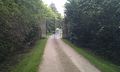
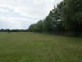
Failed to Gain Access Here Earlier
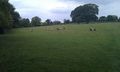
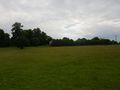
Sheep Field
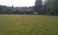
Sheep Field
The Hall Screened by Trees
The Hashpoint
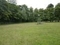
The Hashpoint


Achievements
Sourcerer earned the OpenStreetMap achievement
|
Expeditions and Plans
| 2011-07-03 | ||
|---|---|---|
| Geelong, Australia | Taner | 300 metres into the sea at Clifton Springs |
| Baltimore, Maryland | 1000miles1stStep | Freetown, MD |
| Chełm, Poland | JRK | It was lazy, rainy sunday afternoon. My sister and her husband and their ki... |
| Cambridge, United Kingdom | Sourcerer | 1) In the grounds of Denston Hall 15 km south west of Bury St Edmunds, Suff... |
| Norwich, United Kingdom | Sourcerer | 2) On the west bank of the river Alde east of Iken, Suffolk, UK, logged at ... |
Sourcerer's Expedition Links
2011-06-29 52 1 - 2011-07-03 52 0 - 2011-07-03 52 1 - KML file download of Sourcerer's expeditions for use with Google Earth.