2011-07-03 52 1
| Sun 3 Jul 2011 in Norwich: 52.1440572, 1.5689717 geohashing.info google osm bing/os kml crox |
Contents
[hide]Location
2) On the west bank of the river Alde east of Iken, Suffolk, UK, logged at Wikiloc.
2011-07-03 52 0 :: 2011-07-03 52 1
Participants
Expedition
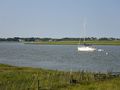
This was my second hashpoint on this day. The three mile walk included the hashpoint which was very near the west bank of the river Alde in a field full of sheep droppings. There were fine views over the river, including a Martello Tower (to prevent invasion by Napoleon if my history is right). Also visible in the distance were the antennas of the Orford Ness short wave broadcasting station used to transmit programmes into eastern Europe.
Photos
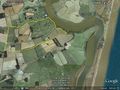
Google Earth Track
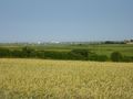
View over the River Alde
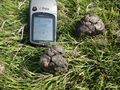
Coordinates Reached
The River Alde
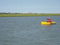
The River Alde
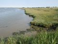
The River Alde
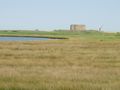
A Martello Tower to prevent invasion by Napoleon
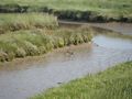
Avocets
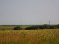
Orford Ness Shortwave Transmitting Station


Achievements
Sourcerer earned the Multihash Achievement
|
Sourcerer earned the OpenStreetMap achievement
|
Expeditions and Plans
| 2011-07-03 | ||
|---|---|---|
| Geelong, Australia | Taner | 300 metres into the sea at Clifton Springs |
| Baltimore, Maryland | 1000miles1stStep | Freetown, MD |
| Chełm, Poland | JRK | It was lazy, rainy sunday afternoon. My sister and her husband and their ki... |
| Cambridge, United Kingdom | Sourcerer | 1) In the grounds of Denston Hall 15 km south west of Bury St Edmunds, Suff... |
| Norwich, United Kingdom | Sourcerer | 2) On the west bank of the river Alde east of Iken, Suffolk, UK, logged at ... |
Sourcerer's Expedition Links
2011-07-03 52 0 - 2011-07-03 52 1 - 2011-07-04 52 1 - KML file download of Sourcerer's expeditions for use with Google Earth.