2011-09-07 49 9
| Wed 7 Sep 2011 in Würzburg: 49.9061485, 9.9727560 geohashing.info google osm bing/os kml crox |
Location
Today's location is in the Gramschatzer Wald forest south of Gramschatz.
Country: Germany; state: Bayern (Bavaria, EU:DE:BY); administrative region: Unterfranken; district: Würzburg rural district
Expedition
Danatar
My plan was simple: Leave work on time at 16:00, drive home and start out by bike around 16:50, reach the general area of the hashpoint around 17:45, celebrate at the hashpoint at around 18:00, cycle home and arrive there at 18:50, take a shower, be at the cinema at 19:30.
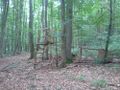
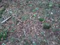
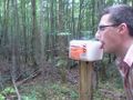
Reality, as always, didn't work out as planned. I had to work until 17:15, which ruled out going to the hashpoint by bike because of the tight schedule. But since this is my third hashiversary, the hashpoint was one I had to get to. So I decided to take a detour by car instead of cycling. The hashpoint was not far from my way home, so I left the Autobahn at Gramschatz exit and parked my car on a parking ground for hikers 3 minutes later. I used my mobile phone to get the coordinates, because I had left the note with the coordinates behind. At the parking ground there was a sign with hiking paths, which I took a picture of....NOT. My camera's batteries had died again. They had been full enough at 2011-09-04 49 9, but I knew that they were getting weak. Luckily mobile phones these days have cameras, too, so I used that one instead. Then I followed the hiking path towards the hashpoint... NOT. From the track on my GPS unit I saw that I was going in the wrong direction, so I turned around and took another path instead. This one was better and I walked along small forest tracks in the general direction of the hashpoint. With some rudimentary memories of the satellite image in my head, I found the forest path that would take me right next to the spot. Next to this track, not far from my goal, I found a salt lick for wild animals. Soon after I was only a few dozen meters from the hashpoint. I took one of the small side track until I was past the hashpoint, then I followed a small fence to the next track, going in a half circle around the hashpoint by doing so, then followed that track back until I was almost at the spot. On the track I heard an angry buzzing and saw a spider fighting with a fly trapped in its net. After a few seconds the fly was able to escape. And there, a few steps away it was: trees around, broken branches/sticks on the ground and the hashpoint in the middle of it all.
From the broken branches I built a marker with "xkcd III" for 3 years of my expeditions. Then I walked back to my car, drove home and went to see The Three Musketeers, which was partly filmed in Würzburg and where a colleague and a few guys from my orchestra took part as extras. I even recognized one of them.
Now it has been three years since my first geohashing expedition (here). In the past year, my third year of geohashing, I:
- visited another 14 hashpoints (out of 14 tries) in 1 new graticule, in 1 new country
- met 2 new geohashers
- cycled 182 km, walked 37 km, used public transport for almost 500 km and motorized vehicles for 92 km
- spent another 89 Euros for geohashing
Danatar earned the Third Hashiversary achievement
|
Danatar earned the Last Man standing achievement
|
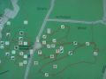
You Are Here
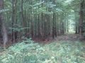
almost there...
GPS
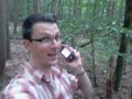
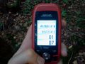
Coordinates reached!
marker
salt lick


