2011-12-23 49 10
| Fri 23 Dec 2011 in Bamberg: 49.7899611, 10.0375325 geohashing.info google osm bing/os kml crox |
Location
Today's location is in a meadow at Rottendorf, not far from Würzburg. It is about 15 metres from the road Danatar uses for bike expeditions in Dettelbach and the surrounding region. A bit further the same road srs0 had a painful experience.
Country: Germany; state: Bayern (Bavaria, EU:DE:BY); administrative region: Unterfranken; district: Würzburg rural district
Expedition
Danatar
As it was the 23rd of December, the plan for the day was driving to my family for the festivities. But with the hashpoint only 8 km from my home, I had to visit it first. I had already cycled past the hashpoint a dozen times, so I knew where to go. The trip was uneventful and I found the hashpoint without looking at the GPS receiver. Then it took only a little dancing to get the correct coordinates on the display. After pictures and some Nibs I cycled home. On my way to visit my family I was planning to visit 48 9 and 47 9.
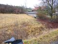
there it is...
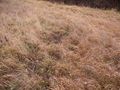
...the hashmeadow!
GPS

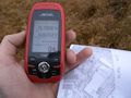
coordinates reached

panorama


