2012-08-01 28 -16
| Wed 1 Aug 2012 in Tenerife: 28.1561241, -16.4748245 geohashing.info google osm bing/os kml crox |
Location
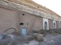
Today's hashpoint is in the countryside near the village Arico, at a building probably used for wine making. I'm not sure whether the building has been built into the hillside or if it just has been covered afterwards. In the region of the hashpoint are many solar and wind power stations.
Country: Spain; region: Canarias (EU:ES:CN); province: Provincia de Santa Cruz de Tenerife; municipio (municipality): Arico
The Canary Islands belong to Spain, but Africa is much nearer (from Tenerife 300 km, from Lanzarote 100 km) than Europe (1000 km). The English wikipedia page says "Geographically it is a part of the African Continent, citation needed". So this might even count as an African expedition. I will not decide this here.
Expedition
Danatar
Prologue: 2012-07-30 not-expedition
For a nice holiday, I went to Tenerife. And, of course, I planned to go geohashing there. Before the there journey, the coordinates for Monday (2012-07-30) were already known and they fell just outside of the giant caldera that surrounds the volcano Teide, only a little off a track. I prepared a map and planned to go there. On that day, I leased a car and went to the Teide national park, visiting all the interesting viewpoints on my way. When around noon I finally arrived at the place north of the hashpoint where the track started from the main road, it was blocked by a barrier. From there it would be a 6 km hike. Every guidebook and the information at the hotel had told me that leased cars tend to get broken into, so I didn't want to leave the car alone on the side of the road for 3 hours. Instead I continued my tour through the caldera. When during the afternoon I was at the Parador hotel, more or less on the other (southern) end of the track, I found that from there the distance would be even longer. So I visited other interesting rocks, went up the Teide and started towards home. When I drove past the northern end of the track again, I again considered visiting the hashpoint. But that would have meant to return home very late, without dinner and probably in darkness. Walking alone and tired, in darkness, at an elevation around 2300 m (after starting at sea level in the morning) didn't seem like a good idea by then, so I returned to the hotel. Disappointed, but alive. The headache that started later (probably from sun, dehydration and the thin air) confirmed my decision as the right one.
2012-08-01
Luckily, other hashpoints fell on land in Tenerife during my stay. Tuesday evening I prepared my GPS unit and made a plan for Wednesday, also informing the hotel that I needed a car again. Wednesday morning after breakfast I started and drove into the Anaga mountains, on the edge of which my hotel was situated. These mountains lie in the path of the trade winds and the higher parts are usually in the clouds, also on this day. That meant that the scenic views were very grey and not scenic. But I visited two of the praised villages and hiked a little along foggy trails through the laurel forest, which was very nice. In the afternoon I continued to Tenerife's capital, Santa Cruz de Tenerife. There I walked around in the city center. Except for the park I didn't like it very much. The "must-see" Conception church was closed at the beginning of my walk and still at the end, so I even missed that one.
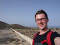
With both the mountains and the city visited and thus my sightseeing program completed, I could start the geohashing expedition at around 5 pm. I drove along the motorway to the Arico exit and through El Porís de Abona to the road that would lead me to the hashpoint. But directly at the edge of that town the road was closed. Oh, well, then I have to hope that the road is open on the other end. To get to the other end I had to take a detour, but I soon arrived at Arico. The road that I took from there was quite straight and new, not like the road I had seen on the satellite image. I soon realized that this one had been newly built and that my maps were now worthless. Of course I drove too far first, had to turn and finally found a small track leading off the road not far from the hashpoint. I left the car there and walked along the track, which after a long curve led to the hashbuilding. The building was built into the hillside, so I could walk directly onto the flat roof. The GPS led me to the edge, with about one metre more to go. So I walked back off the roof and to the lower part of that wall. There I successfully reached the hashpoint. My celebration was just internal because I was very excited: The whole time I was hoping that nobody would talk to me, because my Spanish would not be enough to explain geohashing. I had a photo of the first section of the Spanish geohashing main page on my phone for such a situation. But by now it was 18:30 and all the workers must have gone home long ago, if there was any work going on at all in this place, so I stayed alone the whole time. Not much later I walked back to the car and drove to the hotel.
Danatar earned the Graticule Unlocked Achievement
|
Danatar earned the Hashcard achievement
|
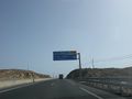
motorway exit
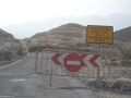
road closed!
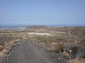
not far now
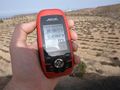
GPS above the hashpoint
there it is
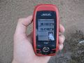
GPS down at the hashpoint
the hashpoint
coordinates reached! Relieved grin
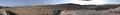
panorama from the top of the building
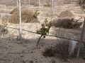
wine growing next to the hashbuilding
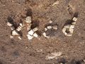
the internet was here
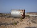
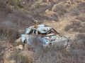
rusty container near the hashpoint
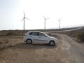
the leased car I used, in the back giant fans are creating a strong wind
Hashcard received by srs0!


tracklog
Triton tracklog (Starting at Santa Cruz. If you want to see the rest of my day, tell me.