2012-08-05 28 -16
| Sun 5 Aug 2012 in Tenerife: 28.0824511, -16.5842084 geohashing.info google osm bing/os kml crox |
Location
Today's location is in the dry countryside near the airport Tenerife Sur Reina Sofia.
Country: Spain; region: Canarias (EU:ES:CN); province: Provincia de Santa Cruz de Tenerife; municipio (municipality): Granadilla de Abona
Expedition
Danatar
It was the day of my return flight to Germany, and the hashpoint fell just 6 km from the airport. This must be a sign, and I will heed it! The original plan for the day was to take a little swim in the morning, then I would be fetched at 13:40 to be transported to the airport for my flight at 17:15. This seemed to short for the expedition, since I certainly didn't want to miss boarding time, not even for a geohashing expedition (yeah, I'm getting old...). So I told the hotel that I would go to the airport on my own.
Three days earlier I had also made my aquaintance with the Tenerife bus system. The buses start at specific times, but there is no schedule how long the ride goes and when the bus will arrive at a certain point. So changing buses is a risky business if you don't have much time. For going to the airport, I had to take a bus to La Laguna, then the next to Santa Cruz and finally the express bus to the airport. From the airport to the hashpoint I hadn't decided yet if I would walk or take a taxi (6 km + 300 m elevation difference is not easy in the heat). Because of that all my plan had a large time reserve between everything. I started at 10 am.
The bus ride to La Laguna and from there to Santa Cruz went fine and was faster than expected. Since the Santa Cruz bus station is not far from the Conception church (which had been closed Monday afternoon), I walked there with my big trolley suitcase. When I entered the church I realized that in such a catholic country as Spain, Sunday 11:15 am is not a good time to visit a church. Well, in fact it is a very good time to visit a church, just not for sightseeing... I sat down in the last row, listening to the sermon and looking around the church for 10 minutes, then I went back to the bus station. The bus arrived at the airport around 12:45. I went to the check-in counter to check in my suitcase, but there was nobody there. The information desk informed me that the counter would open 2 hours before takeoff, at 15:15. So I had to take the suitcase with me on the geohashing expedition.
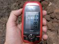
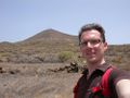
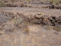
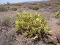
Pulling it for 6 km on its tiny wheels didn't seem very funny, so I took a taxi and let me be taken to the "Restaurante Avestruces de Tenerife". This ostrich breeding farm with restaurant was about 1 km from the hashpoint. I told the waitress that I'd like to eat there, but that I wanted to take a walk first and they allowed me to leave the suitcase there. I walked along the road towards the hashpoint. I left the road next to a walled estate where I could hear many voices and walked across the dry countryside with only cactuses, dry grass, other dry plants and every few metres a tiny wall terracing the slightly sloped area. The hashpoint was reached easily, I took the usual pictures and walked back to the restaurant. There I ordered ostrich with vegetables and the Canarian specialty papas arrugadas, which turned out to be a very large portion and tasted fine. Afterwards I ordered a taxi and was taken back to the airport.
By now it was 15:00 and there was already a very long line at the check-in counter. The flight to Frankfurt was fine and ahead of schedule. I had to wait a bit for my suitcase, then took the suburban train to the small town where I had parked my car (for 0 Euros instead of the >100 Euros it would have cost directly at the airport) and drove home, where I arrived at 01:30.
In total I went ~93 km by bus, 8.5 km by taxi, 3200-3300 km by plane, ~4 km by train, ~134 km by car and ~3 km on foot. No wonder I was tired when I arrived at home...
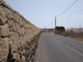
walking along this road
GPS
coordinates reached!
the hashpoint
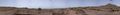
panorama
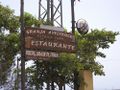
this place...
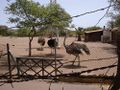
...converts these ostrichs...

...into tasty food
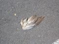
the wings of death
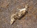
more death


tracklog
Triton tracklog (starts and ends at the airport)