2012-08-07 -35 149

| Tue 7 Aug 2012 in -35,149: -35.3455808, 149.1434366 geohashing.info google osm bing/os kml crox |
Location
Hindmarsh Drive (inside lane), at Narrabundah (Canberra), between Dalrymple Street (becomes Mugga Lane) and Jerrabomberra Avenue. Near the south-west corner of Capital Golf Club.
NOTE: Someone should do the hash one grid south (2012-08-07 -36 149) as it is also a drive-through hash, on the Myalla Road south of Cooma.
Participants
Plans
I saw this was on the four-lane road, on the "inside" (non-curb) lane. I could travel only about 6-7km from work, during my lunch time.
Expedition
1PE
I prepared the car at a pull-off a bit before the stretch of road:
- map on the dashboard;
- rear mirror positioned so my face would also be caught by the camera.
I passed along the other lane(s) and photographed where the hash was, then turned into the side road, Mugga Lane, in order to double back and turn into the inside lane. I waited at the traffic lights behind a large truck, then turned with it into Hindmarsh Drive. The truck took the curb lane and I accelerated down the hill towards the hash.
I took several pictures as I approached the hash.
Photos
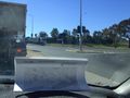
Mugga Lane corner, ready to turn onto Hindmarsh Drive and the hash. The truck is returning empty from the landfill on Mugga Lane.
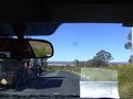
Hash at 80km/h is ahead ~100m - Hindmarsh Drive; note the mirror!

Achievements
1PE earned the Speed racer achievement
|
NOTE: Someone should do the hash one grid south (2012-08-07 -36 149) as it is also a drive-through hash, on the Myalla Road south of Cooma.