2012-08-20 52 -0

| Mon 20 Aug 2012 in Northampton, UK: 52.1831237, -0.0955624 geohashing.info google osm bing/os kml crox |
| This expedition was part of a multihash by Benjw. For the other parts, see: | |||||
|---|---|---|---|---|---|
| 2012-08-20 52 0 | 2012-08-20 52 -0 | ||||
Location
On the edge of a field in Longstowe, a village west of Cambridge. The hash itself should be accessible by walking round the edge of the field from the bridleway to the south.
Participants
Plans
Ben plans to cycle up from Cambridge in the afternoon, aiming for approximately 3pm at the hashpoint. It should be slightly cooler by that time! Probable route is out of Cambridge on the Madingley Road, collecting a few geocaches in Hardwick and Bourne, depending on how much time I have after finishing work at lunchtime. Once this hash has been attempted, the return route will be through Toft and Barton, and over to Grantchester to attempt the Cambridge graticule hash.
Expedition
After leaving the 52,0 hashpoint, I cycled through Grantchester and then west towards Barton on a bridleway. I crossed the motorway, but happily there was a bridge provided and I didn't have to run for it. On the far end of the bridge a geocache was hidden, so I obtained a coded message from this for the next stage of the cache, and then resumed my hashing mission.
I've cycled along this road before. All the way out from Cambridge, through Barton and as far as the edge of Comberton, there is a lovely wide cycle path to ride on, instead of the road. Then, when you get to Comberton the cycle path disappears and you have to just take your chances with the rest of the traffic after that. I did so. The road is fairly flat, but I was not going quickly, and soon I realised I was starting to struggle badly. Although I walk a great deal and cycle short distances daily, I do not often go for long bike rides any more, and after yesterday's 51 km effort, my legs were protesting.
After Comberton, I reached Toft; and after Toft, I stopped for another breather as the prospect of another geocache came up. This was another puzzle cache, and was hidden in a tree along a very nettle-y path from the road. (All my expeditions at the moment seem to involve copious stinging nettles!) Another three kilometres on, I was seriously flagging again, and on reaching the turning for Bourn I took the opportunity of finding the village shop for -- in no particular order of importance -- chocolate, a cola-flavoured beverage containing caffeine, and a ten-minute rest-stop.
Whichever one of those worked, I don't know; but happily, one of them did, and I felt a lot better for the last three kilometres or so of my outward journey. I finally reached Longstowe just before quarter to five, having taken over 70 minutes to cycle just 15 km along fairly flat terrain.
The hashpoint was in another field, so I walked along a bridleway from the centre of the tiny village, then turned off along the edge of a field, and found that I had to cross a ditch to get into the field I wanted. It has been rather hot lately, so the ditch was almost dry, with only a centimetre or two of squelchy mud in the bottom, but it was the large quantity of nettles (more stinging nettles!) that worried me, rather than the mud. After a while scouting out other possible routes I decided that the quickest option was just to go for it, so I left my bike by the side of the ditch and clambered across as best I could in shorts and T-shirt.
The hashpoint itself was then another 400 metres or so round this new field, which gave the nettle stings time to wear off. The hash was duly reached and recorded, and I spent a few minutes just standing on the spot, wondering at how quiet it was out here. I heard the wind in the trees at the edge of the field, and a bird of prey screamed from the middle-distance. After a while I heard the rumble of a tractor a long way away, but that was about it. I set off again having quite enjoyed the hashpoint, despite not caring much for the journey here.
The way home was a lot easier. Perhaps I had a slight tail-wind on the way back, or maybe I was just still high on caffeine and chocolate, but the 23 km ride home took less time than the 15 km ride out. It was perhaps also fortunate that the next two days' hashpoints were a long way from Cambridge, and I was not tempted to visit...
Total distance cycled today turned out to be 46.7 km, with two hashpoints and five geocaches. Not the most successful of bicycle expeditions, but I made it there and back, and in approximately one piece, so it could have been worse.
Photos
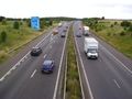
Crossing the busy M11 motorway.
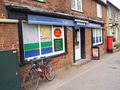
Stopping for much-needed sugar and caffeine.
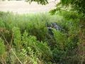
Leaving the bike by the ditch full of mud and nettles.
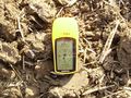
Proving I was here.
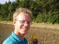
Smiling because I was here.
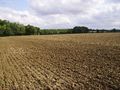
Looking east from the hashpoint.
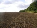
Looking west from the hashpoint.


Achievements
Benjw earned the Land geohash achievement
|
Benjw earned the Bicycle geohash achievement
|
Benjw earned the Multihash Achievement
|