2012-08-20 52 0

| Mon 20 Aug 2012 in Cambridge, UK: 52.1831237, 0.0955624 geohashing.info google osm bing/os kml crox |
| This expedition was part of a multihash by Benjw. For the other parts, see: | |||||
|---|---|---|---|---|---|
| 2012-08-20 52 0 | 2012-08-20 52 -0 | ||||
Location
On the edge of a field in Grantchester, a village just outside Cambridge to the southwest. The hash itself should be accessible by walking along the hedge from the footpath to the east or the road to the west.
Participants
Plans
Ben plans to cycle up from north Cambridge in the afternoon, after work, via a fairly circuitous route passing through Hardwick, Bourne, the Northampton graticule hash in Longstowe, Toft and Barton. He will be aiming for the canonical 4pm meet time at this hashpoint. Once this hash is attempted, the rest of the planned route is a very simple meander back into Cambridge along the river path.
Expedition
After yesterday's fun, it was a shame that my plans and Ali0sha's plans didn't gel today, but that's life. Today's point was a few kilometres south-east of yesterday's hash; and, like yesterday, close enough to the prime meridian to make a double bicycle expedition possible.
Work was extremely quiet, since it's the middle of the summer, and I was able to leave just before 11:00. I got home, made lunch, got the bike ready, answered emails, faffed around a lot and generally didn't leave the house. Right about the point where if I delayed any longer I might as well not go, I finally worked up the enthusiasm to leave. It was six minutes to three.
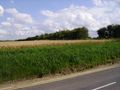
I started the same way as yesterday -- heading towards the centre of town, and turning right when I reached the river. But instead of continuing out to the west like yesterday, today I followed the river as it bent round to the south, and headed out of town through Grantchester Meadows. This is basically a series of fields and paved paths on the west bank of the river, stretching the 1500 metres between Cambridge and Grantchester, and it's a popular spot for walking, cycling, picnicking and grazing cattle. I saw lots of walkers (some with dogs) several cyclists, a couple of canoeists on the river, but only one cow today.
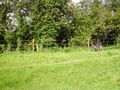
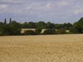
Just before I reached the village, I swung right to follow the edge of a meadow out to a parallel road. The hashpoint was on the edge of this field. Indeed, I hoped it was in this field, because there was a barbed wire fence running along the edge of it -- one of the new-looking, efficient kinds, not the old, falling-to-bits sort you can step over. My hoping didn't really help, because it wasn't in my field; it was nearly 10 metres over the fence, through barbed wire, hedgerow and ditch. Bah. I took a photo of the fence with my bike leaning against it.
But wait! -- the field with the hash in it was just crops. Why would there be a fence around that? Surely the fence is more likely to be required to keep the cattle in their field than to keep geohashers out the crop field? I carried on to the corner of the meadow, carried my bike over a stile (to the amusement of three people sitting outside the pub across the road) and walked up the road a few metres. Yes, I was right. (I made a note to tell MrsBenjw of this rare occurrence later.) The crop field had no fence at all and access would be as easy as climbing up a bank infested with stinging nettles and brambles. Which is what I did. (Ouch.)
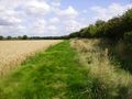
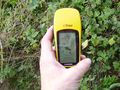
The field had a wide strip of grass along the edge, and I simply walked along this until I found the right spot for the hash. The hashpoint itself was a little into the (again, quite thorny) hedge, but by pushing myself into this (again, ouch) I got well within the magic three-metre circle. Suitable photos were taken and I walked back to the road.
Upon trying to exit the field the same way I'd come in, I seem to have been set upon by tiny but vicious raptors. They attacked so fast I couldn't get a photo, but one of them broke its claw off while attacking my leg, and I recorded the evidence for posterity. It was now half-past three and I needed to make tracks for the 52,-0 hashpoint, so shrugging off this minor flesh wound, I returned to the bike and carried on. So far I had cycled 7.25 km, but there was a lot more to come.
Photos
No access this way. Am I thwarted?
No! I can reach it this way instead.
Walking up the side of the field.
Proof of hash.
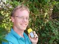
Yay!
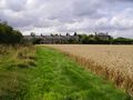
Looking back towards the houses on the edge of the village.
You can just see Cambridge over the trees.
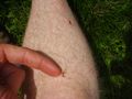
The aftermath of the raptor attack.


Achievements
Benjw earned the Land geohash achievement
|
Benjw earned the Bicycle geohash achievement
|
Benjw earned the Consecutive geohash achievement
|