2012-09-12 52 -0

| Wed 12 Sep 2012 in Northampton, UK: 52.4066561, -0.1910491 geohashing.info google osm bing/os kml crox |
Contents
[hide]Location
A field north of Wennington, north of Huntingdon.
Participants
| This expedition was part of a multihash by Benjw. For the other parts, see: | |||||
|---|---|---|---|---|---|
| 2012-09-12 52 0 | 2012-09-12 52 -0 | ||||
Expedition
Benjw
Just before we reached the previous hashpoint, I'd got mud and grass stuck in my bike's derailleur, and this had caused the chain to jam and snap the gear selector cable, causing the bike to be stuck in one gear, which happened to be the second-lowest. I explained this to Dr-spangle, but he was all for attempting the second hash anyway. The rain had stopped and I didn't have anything pressing to do that evening, so I agreed, and we set off.
As we cycled back to the main road, upon which we were to turn right and head towards Sutton, we found that with my broken bike, my cycling speed and Dr-spangle's cycling speed were actually not too dissimilar -- indeed, I was going faster than he was. We were managing a fairly steady 16 kph or so, which would get us to the next hashpoint in two hours, and it would take us both two hours to get home after that. This would take us to 9:30pm, which is not excessively late. I commented on this, and added that I was grateful that I'd remembered to bring my bike lights, as it would be dark long before then. "Um," pointed out Dr-spangle, "I haven't. Well, I've got one."
Plan B -- consisting of cycling the short distance to Ely and getting the train to Cambridge, where I would pick up my car and drive us and Dr-spangle's bike to the hashpoint and then home -- was briefly discussed but dismissed. We would go on. We did so. The main road was not too bad to cycle along, but it wasn't wide and the cars passed by pretty quickly, so I was grateful when a cycle path appeared at the side of it. After a while this led us off to the other side of some vegetation and when we found the road again it took us a little while to realise that the path had taken us onto the side road into Sutton that we actually wished to take, without us noticing.
Sutton village made a pleasant change from the main road, and contained a small hill which we enjoyed descending. Then we left the village and embarked upon the long, straight road to Earith. I don't remember exactly when it started to rain again, but this time it quickly progressed past the drizzle stage and onto proper rain. There is no shelter out on the Fens, and we were quickly completely drenched. It was getting darker, and I could barely see through the rain on my glasses. Soon, even my underwear was soaked, and that makes for very unpleasant cycling. Our cycling speed had also taken a battering and we were barely going at 13 kph by now. By the time we reached Earith, I was a bit fed up. We pulled up outside a corner shop in the village and had a brief discussion, agreeing that had it not rained, we probably would have carried on to the hashpoint, but as it was, it was probably more sensible to stop.
Dr-spangle left a message with his father enquiring about the possibility of a lift home, and we walked a short distance up the street until we found the nearest pub. This was called the Riverview Inn, and although it wasn't very warm or cosy, it was open and had a ceiling, which was a distinct advantage at the current time. It even sold Real Beer too, which was a bonus. I had a pint while Dr-Spangle preferred a cola-flavoured beverage. We sat and didn't dry off very much, but at least we were inside and it was marginally warmer. We checked the maps, Dr-S found some internet and we tried to locate some public transport that was working at this time of night (all of 6:30pm). There was none.
Drinks finished, we eventually wandered outside to find that the rain had stopped and the sun was starting to set, turning the rain clouds bright orange. Dr-spangle's dad phoned back to confirm his lift, and the two hashers parted ways, Dr-S to wait for his dad and me to make my slow way home by bike, in second gear. I headed half a mile or so back the way we'd come until I reached the turning for Willingham, then headed that way, turning onto the guided busway in Longstanton and reaching home again at about 8:25pm. For the start of this leg of the journey I did try to go as quickly as I could, but I had a top speed of about 24 kph, and that was with a cadence of 107 rpm, so I quickly gave up on that and settled at about 18-20 kph. It made for a long journey but at least it wasn't raining any more, and the sunset was nice.
Once I got home, a hot shower had never felt so good. I'd ended up cycling over 60 km today, but Dr-spangle had done at least 75, which was an excellent effort. I gather he "slept most of Thursday" -- lucky thing!
Postscript
The furthest west I (Ben) got on this trip was the point where we locked our bikes up outside the pub, which was at 52.35400 North, 0.03395 East -- i.e. in 52,0, the Cambridge graticule. Since I'd started out from Cambridge and we'd gone to the Cambridge hashpoint first, I never even made it into the right graticule for this hashpoint, let alone anywhere near the hash itself. So a bit of a complete failure as far as I was concerned -- at least Dr-spangle actually made it to both graticules...
Photographic documentation
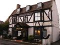
The pub where we called off the expedition.
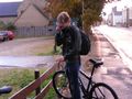
Dr-spangle phoning for a lift home.
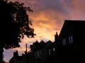
Sunset through the rain clouds.


Shiny Mildly tarnished ribbons
One we didn't really want. Oh well.
Benjw and Dr-spangle earned the Done with Nature consolation prize
|