2012-09-16 42 -90
| Sun 16 Sep 2012 in 42,-90: 42.8753873, -90.2573592 geohashing.info google osm bing/os kml crox |
Location
Cow pasture west of Mineral Point, Wisconsin, just south of County Highway E
Participants
- SwensonJ,
- wife, and
- kids
Plans
SwensonJ makes his first attempt at a geohash.
Expedition
tl;dr Pessimism yields to reality!
After looking at the Google satellite map, I had pretty much convinced myself I was heading for a No trespassing consolation prize, or at best the center of a field of corn: the least distinctive scenery southwest Wisconsin has to offer. Nevertheless, I convinced my wife and kids to pile into the minivan for an early afternoon drive.
It was a beautiful day to be on the back roads: cloudless and 73oF (23oC), with hawks circling over the soybean fields. We backtracked, trying for a photo of one big hawk who was acting as fencepost sentry, but we missed him. Sorry, Internet.
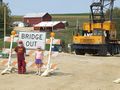
The GPS directed us flawlessly to the edge of a cornfield surrounded by barbed-wire fence. I was astonished to see a farm access road open up just at the road's nearest approach to the hash point. We ditched the van at the gate and walked south, pushing through the tall weeds and thistles along the fence line between the corn and the soybeans, eventually dead-ending at an empty cow pasture fenced in barbed wire. (When I say "empty," I mean there were no cows in it. There was a good deal of evidence that cows had once been there.)
Working our way east along the fence, we attained the desired line of longitude, but were still 70m north of the goal. Ah -- but way down at the end of the fence -- a cattle gate! We climbed it, jumping over most of the thistles on the other side.
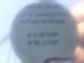
Crossing the cow pasture was a luxury after fighting through the weeds. A five-minute walk brought us within a few millionths of a degree of the hash point, where I started my flirtation with the Blinded by Science ribbon. Apparently it is not so easy to take an extreme close-up photograph of a GPS screen in full sun, if you're hoping to be able to read the display in the photo. Spoiler: the trick is to ask your wife how to do it.
It was also interesting to learn that the calculated coordinates shift over time, even when the GPS isn't moving. This is understandable, but it added a certain tension to the photography lesson, which was further heightened by a child asking, "How long is this going to take?" Luckily we were able to redirect that child into an attempt to catch a cricket. Eventually (1:45 p.m.) all was accomplished, our Stupid Grins were captured, and the party began to retrace its steps.
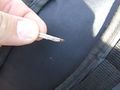
At this point we learned, as we should have known, that velociraptors target smaller individuals and stragglers. In short, my wife was ambushed. The raptor was not visually identified, but it lost a claw in my wife's shin. My foresight in carrying Band-Aids was much admired, somewhat compensating for my (deprecated) desire to photograph the claw before it was removed from my wife's body.
We returned to the van without further incident. I am happy to report that all four times I came within 5m of a skunk, it walked away from us without manifesting any aggressive impulses. The herd of cattle that materialized near our parking spot seemed to harbor more violent urges, but happily they were on the other side of a fence from us.
On the drive home, all family members reported having enjoyed the adventure. Both children added that they were not at all tired.
Photos
The drive was mostly pleasant.
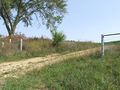
A gate appears just where it's needed!
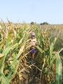
Small people can walk between rows without breaking down the stalks.
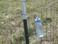
The bottle marks the goal meridian: just 70 meters to go.
Crossing into the cow pasture
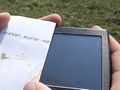
Can't...
...photograph...
...the...
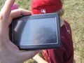
...GPS...
...screen
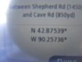
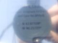
Proof of success!
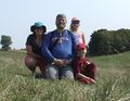
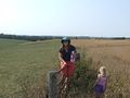
Stupid Grins at the hash point
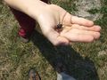
the distracting cricket
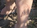
Raptor claw!
Blood sample
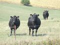
Cattle contemplate our murder
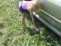
Picking up roadside litter
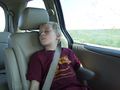
My son was not tired.
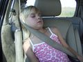
My daughter was not tired.


Achievements
SwensonJ earned the Land geohash achievement
|
SwensonJ earned the GeoTrash Geohash Achievement
|
SwensonJ earned the Velociraptor Baiting Achievement
|