2013-04-28 52 1
From Geohashing
| Sun 28 Apr 2013 in Norwich: 52.2958254, 1.4715725 geohashing.info google osm bing/os kml crox |
Contents
[hide]Location
500 metres east of the water tower near Sibton Green, Suffolk, UK.
Participants
Expedition
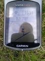
- Arrived. -- Sourcerer (talk) @52.2958,1.4716 16:32, 28 April 2013 (GMT+01:00)
The hashpoint was beside a public footpath 500 metres east of the water tower and roadside parking place. It was a cold spring day with a penetrating breeze but many spring flowers were coming into bloom. Nice.
Tracklog

Photos
The Evidence
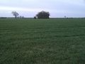
View from the Hashpoint
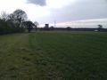
Land Mark


Expeditions and Plans
| 2013-04-28 | ||
|---|---|---|
| Ballarat, Australia | Snaplatitude, a McDonalds Employee | A private paddock in Lexton |
| Springfield, Massachusetts | Todd | A quarter mile into a forest off Harris St/Harris Mountain Rd in Granby nea... |
| Houghton, Michigan | Someone went | On the Keweenaw peninsula. |
| Innsbruck, Austria | LeslieHapablap, EleanorAbernathy, Waltraud | On a meadow in the middle of the village Thaur, opposite to the priest's of... |
| Frankfurt am Main, Germany | QuarterCacher, LadyBB, EmmJay, Mampfred | On a little strip of grass near Schmitten. Better known as "in the pampa". |
| London West, United Kingdom | KennethCC | A muddied rut at the side of a narrow country lane outside Ockham in Surrey... |
| Leipzig, Germany | Bazaruto | Small wood near Holzhausen. |
| Eindhoven, Netherlands | Wythnir | In the bushes next to a small road near Schaft. |
| Birmingham, United Kingdom | Bollerenshaws | In a farmer's field north-east of Offchurch near Leamington Spa, UK. |
| Norwich, United Kingdom | Sourcerer | 500 metres east of the water tower near Sibton Green, Suffolk, UK. |
| Amsterdam, Netherlands | Murfie, Palmpje | Langevelderslag, The Netherlands |
| Karlskoga, Sweden | the ru, Thomas | In a forest just outside Karlskoga. |
Sourcerer's Expedition Links
2013-04-17 52 1 - 2013-04-28 52 1 - 2013-05-27 52 -2 - KML file download of Sourcerer's expeditions for use with Google Earth.