2013-12-29 36 -4
| Sun 29 Dec 2013 in Málaga, Spain: 36.7846778, -4.1664268 geohashing.info google osm bing/os kml crox |
Contents
[hide]Location
In an avocado orchard close to Benamocarra, Málaga, Andalucía, Spain.
Participants
Expedition
Sourcerer visited this hashpoint 1798 km from home. He was on holiday in Spain with geohashing as one of the holiday activities so perhaps this distance does not really count. The expedition needed a train ride from Benalmadena to Malaga and a bus ride from Malaga to Velez Malaga. Then there was a 6.5 km walk to the hashpoint. The return trip was the same in reverse taking about nine hours in total. This was a nice way to see a tiny part of Spain and get a walk in sunny weather at a nice temperature.
Achievements
This is the first known expedition in this graticule.
Sourcerer earned the Graticule Unlocked Achievement
|
Sourcerer earned the OpenStreetMap achievement
|
Photos
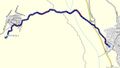
Walking Route Track Log in Garmin Mapsource
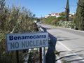
Benamocarra Village No Nuclear Sign
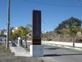
Benamocarra Village Sign
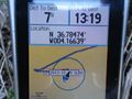
Proof
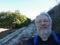
Selfie
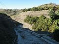
Hashpoint Terrain
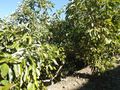
Avocado Orchard
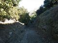
Access Lane
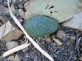
Avocado Wind Fall

Velez Malaga Bus Station Nearby
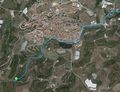
Track Log in Google Earth


Expeditions and Plans
| 2013-12-29 | ||
|---|---|---|
| Melbourne East, Australia | Lachlan Gordon, Felix Dance | On a street in Donvale in Melbourne's East |
| Jerusalem, Israel | Omri | At the forest right next to the road leading to Beit Zait, a small town on ... |
| San Diego, California | JesseW | On W. Dunlop St., near 2218 Dunlop St. in Linda Vista. |
| Málaga, Spain | Sourcerer | In an avocado orchard close to Benamocarra, Málaga, Andalucía... |
| Roseburg, Oregon | Michael5000, Mrs.5000, Niece #4 | Off Gowdyville Road in the woods west of Cottage Grove. |
| Vancouver, British Columbia | Wijnland | Just North-East of Barriere, BC. Canada |
| Cache Creek, British Columbia | Wijnland | Just North-East of Barriere, BC. Canada |
| Globalhash | Wijnland | Just North-East of Barriere, BC. Canada |
Sourcerer's Expedition Links
2013-09-28 52 1 - 2013-12-29 36 -4 - 2014-01-04 37 -3 - KML file download of Sourcerer's expeditions for use with Google Earth.