2014-07-14 -12 130
| Mon 14 Jul 2014 in -12,130: -12.4024204, 130.8453082 geohashing.info google osm bing/os kml crox |
Location
Just off the coast of Ludmilla, Darwin.
Participants
Expedition
I saw this interesting and seemingly accessible geohash on Saturday and immediately halted all plans for the Monday evening. I was soon informed by my friend Lachie that there was also a (somewhat) accessible GLOBOHASH that very same day. Spending some seconds weighing up the two I sadly decided to ditch the globohash and concentrate on the local one (the 3,000 kilometre round trip drive required for the globohash had something to do with the decision).
Setting out after work on my bike towards the hash, my erst-while companion Bec having abandoned me for the preferred activity of sleep, I came to a sign on a gate warning me of an Aboriginal burial ground in the vicinity. I justified my continued hashing by finding the sign unspecific as to the extent of the burial ground and I planned to enter via the back way.
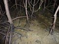
Making my way around the hash-area to the beach I soon realised the hash would be far harder than predicted. The beach was entirely covered in mangroves and vegetable detritus impairing access. My road bike was no match for the sand and swampland and I had to push it along for about a km. When I got to the closest beach access I discovered an even bigger problem: the hash was 60m out to sea through croc-infested mangrove marshland.
At this point I gave up. Only a few weeks ago a man was ripped out of his boat in a park near Darwin and torn literally in two by competing crocs. Several times a year people from this town are consumed by these dinosaurs and I was in prime crocodile territory. Getting into the water was not an option.
But just as I was about to walk away I thought 'Stuff it', and suddenly found myself taking off my shoes and socks, donning my bike light, GPS and phone and venturing out into the marsh.
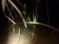
It was a surreal and creepy experience. The tide was up and waves washed in and out around the gnarled mangrove forest. My feet sunk into the mud, feeling the mangrove root tentacles and the pointy shells of buried hermit crabs. I bristled at every un-sourced sound: splashes, squelches, bubbles, rustles and murmurs. Occasionally, the mud next to my submerged legs would erupt in spurts of entrained air and something lizard-like would eject from a hole and swim away. I was a feeding-bonanza for insects of all shapes, sizes and hums.
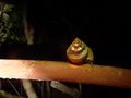
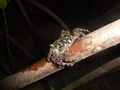
It took me half an hour to venture the 60m out into the ocean, with the water around my legs getting deeper and more impenetrable. Soon I turned left into the thick mangrove forest and was entirely concealed from above. Clambering over the roots and squelching through the mud I arrived at the hash in a triumph. I took photos and sent text messages. It was now that I realised the tide had receded substantially and I was surrounded by a mud-field.
I returned tentatively, taking another half-hour of clambering and freaking out at strange noises, once getting turned around and venturing another 20m out to sea, before I finally arrived back on the beach. My bike was some distance away, flashing its beacon. I walked back and rode home, arriving just after 10pm.
Covered in sand, mud and insect bites I told the story to my housemate - a Darwinian ecologist (i.e. an ecologist born in Darwin) who knows the area intimately. He was shocked: "You really could have been taken by a croc out there!" he assured me. It took a couple of shots of gin to get to sleep that night.
I rode 14.6kms and reached the hash at 8:40pm.
Here is the route of my trip.
Photos
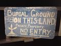
Burial ground sign
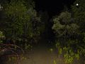
Mangrove-hash!
Wading towards the hash
Hermit crabs everywhere

Felix at the hash
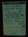
GPS proof
Receding tide on the way out
All sorts of crabs
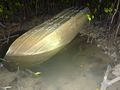
Upturned boat - note bullet-holes from unsuccessful defence against croc attack
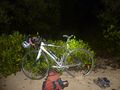
Waiting bike
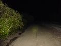
Beach walk home


Felix Dance earned the Bicycle geohash achievement
|
Felix Dance earned the Water geohash achievement
|