2014-08-18 52 1
| Mon 18 Aug 2014 in Norwich, UK: 52.0315647, 1.2790066 geohashing.info google osm bing/os kml crox |
Location
In a wheat field, close to a public footpath east of Bucklesham, near Ipswich, Suffolk, UK.
Participants
Expedition
This was hash one of a doublehash. Sourcerer went by car, south along the A12, bypassing Ipswich. Where the A12 meets the A14 between Felixtowe and Ipswich, there is a small village called Bucklesham. There was a place to park opposite the village school and a footpath, presumably used by the children during term time. The footpath headed north across newly planted crops. Very few walkers had been that way since the planting. The field had been ploughed into deep grooves normally used for potatoes or asparagus. However the crop was something else, not possible to identify in the dark. It was raining enough to need an umbrella, just to keep the droid phone dry. As predicted on foonetic, the hashpoint was in a harvested wheat field and very easy to reach. The red lights, warding off aircraft, could be seen on the telecommunications tower at the Martlesham research station. The arrival time was 23:00 as planned. Stage two: head for 52, 0 for a midnight geohash.
Photos

The harvested field and telecom tower lights.
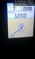
Arrived. @52.0315,1.2790
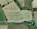
Track in Google Earth


Achievements
Sourcerer earned the Last man standing achievement
|
Sourcerer earned the Two to the N achievement
|
Expeditions and Plans
| 2014-08-18 | ||
|---|---|---|
| Newark, New Jersey | Someone went | A front yard in Wharton |
| Norwich, United Kingdom | Sourcerer | In a wheat field, close to a public footpath east of Bucklesham, near Ipswi... |
Sourcerer's Expedition Links
2014-08-12 52 1 - 2014-08-18 52 1 - 2014-08-19 52 0 - KML file download of Sourcerer's expeditions for use with Google Earth.