2014-10-03 37 -122
| Fri 3 Oct 2014 in 37,-122: 37.9881930, -122.5546873 geohashing.info google osm bing/os kml crox |
Location
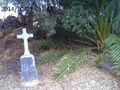
Mt. Tam cemetery north of San Rafael
Participants
Plans
Pretty much the same as for 2014-01-26 38 -122: take public transit across the Richmond-San Rafael Bridge to the transit center thereof, then switch buses to one heading in the right direction. The subsequent footwork would be a bit more involved than in the aforementioned geohash, since this one was to be found not on a bus route, but across a hill from the closest one. Accessibility also looked promising: surely I would be allowed to a specific point in a cemetery on a weekday.
Expedition
Alternative title: "How I came to believe I was locked in a cemetery with a partially emptied bag of gluten-free ginger snaps when this was not, in fact, the case."
I wasn't free to go until the afternoon, thanks in part to a physics lecture at which I provided snacks. I think I did a good job of that: out of five or six different snack foods, three of them had leftovers. I had these (pecan cookies, barbecue-flavored potato chips, and ginger snaps) with me on the expedition primarily because I didn't take time to drop them off at home and secondarily because it's nice to have snacks around.
The bus-based part of the trip passed without incident. While walking to the cemetery, I made a wrong turn and had to backtrack, but that was not too much a problem. I got to Mount Tamalpais Cemetery just after 5, and hesitated: although the gate across the cemetery driveway was open, a sign clearly stated the closing time was 5 PM. I decided, rather self-servingly, to take my cue from the gate and entered, prepared to vacate the property at the slightest request.
I had been aware that the geohash was in a tree-covered part of the graveyard; upon reaching it, I discovered the reason for leaving a grove at that location instead of using it for graves. It was on a steep hill. I found it difficult to get a good GPS fix, owing to the trees and hilly terrain, so a lot of running up, down, and around the slope was required. Eventually I got a good enough reading and picture to declare the expedition successful.
The briefly scary part of the day came on the way back. As I headed back out of the cemetery, I saw that the gate had been pulled closed across the entrance. My only visible means of escape was to climb over it, which was easier than it may sound, as the gate was no more than four feet high. So I did that. In the process, I detected an unexpected wobble, and once on the outside checked the integrity of the structure.
The gate was now opened a few inches. In fact, there had never been anything holding it closed. I had been free to push it open and walk out the whole time.
There was another moment of panic once I got to the bus stop and saw the first bus passing in the right direction was out of service. But there were more after it, and I got home as planned.
Tracklog
Photos
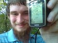
The GPS is pretty readable here, but it's not the closest I was able to record...
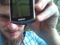
...this is.
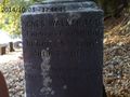
The closest grave marker to the geohash is that of Agnes Walker, M.D., as well as three older relatives. Agnes is the one on the side facing the hashpoint.
The geohash is among the fronds. I don't recall a name on the marble cover, so Agnes gets the Coffin Geohash.


Achievements
Codae earned the Land geohash achievement
|
Codae earned the Public transport geohash achievement
|
Codae certifies that Agnes Walker, M.D. earned the Coffin Potato Achievement
|