2015-01-01 28 -16
| Thu 1 Jan 2015 in Santa Cruz de Tenerife, Spain: 28.3362715, -16.3794324 geohashing.info google osm bing/os kml crox |
Location
West of the autopista near la playa de Socorro, Santa Cruz de Tenerife, España.
Participants
Expedition
This hashpoint was 3000 km from home. I walked about 1 km from my holiday accommodation to the Estacion de Guaguas (Bus Station) and caught the 10:30 guagua to Costa Adeje. A change of guagua was needed. I took the 111 to Santa Cruz via the south airport. I got off at Arafo (Bus Stop 7120) and started the short walk. On Google Earth, the hashpoint looked as though it was half way up a steep slope. In real life this turned out to be a low vertical cliff. Luckily the hashpoint was at the bottom and easily reached. It was in the middle of a euphorbia bush. The circular route back to the bus stop totalled about 3.5km. The return bus journey was similar with the change of bus in Los Christianos because that is a nicer place to wait. Very little time was lost waiting for the buses.
The sky was very hazy due to fine dust blowing in from the Sahara desert. The locals call this weather Kalima. In the summer this weather is very hot and windy. In January it's warm but not too pleasant due to the dust.
Achievements
Sourcerer earned the OpenStreetMap achievement
|
Photos
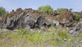
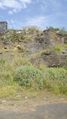
Eroded Lava Flow
Banana Plantations
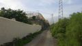
Quarry and Industrial Estate
Proof
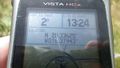
The Hashpoint was in the fresh green bush.
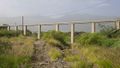
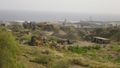
Aquaduct and Mount Teide in the Sahara dust gloom
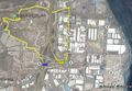
Track Log in Google Earth


Expeditions and Plans
| 2015-01-01 | ||
|---|---|---|
| Rosario, Argentina | Onicofago, Kid, one of our nephews, Santiago. | In a crop field near RP11 which connects Diamante and Victoria. Province of... |
| Melbourne East, Australia | cbjaust | Next to a dam behind the house at 241 Margetts Rd Flowerdale/Yea 3717, Vic,... |
| Santa Cruz de Tenerife, Spain | Sourcerer | West of the autopista near la playa de Socorro, Santa Cruz de Tenerife, Esp... |
| Mannheim, Germany | DODO | In the forest near Speyer, just 4 KM from DODOs home. |
| Leipzig, Germany | TheOneRing | in the center of Leipzig. |
| Kassel, Germany | GeorgDerReisende | The hash lay in the forest Habichtswald west of Kassel. |
Sourcerer's Expedition Links
2014-12-28 28 -16 - 2015-01-01 28 -16 - 2015-01-09 52 0 - KML file download of Sourcerer's expeditions for use with Google Earth.