2015-02-05 52 1
| Thu 5 Feb 2015 in Norwich, UK: 52.8239232, 1.1753055 geohashing.info google osm bing/os kml crox |
Location
In a field a close to the river Bure and Itteringham, Norfolk, UK.
Participants
Expedition
Party tickler blow - Wheeeeeeeeee! This was Sourcerer's 100th expedition in 52,1.
This was another North Norfolk hashpoint without 3G access so the live "Arrived" message could not be sent.
I set out by car at about 9pm and came close to the hashpoint by 10pm. It was quite easy to follow the perimeters of two fields to reach the hashpoint. Tractor tracks were used for the final approach. It was nice to see very wide field margins for ground nesting birds. The temperature was 2 Celsius and there was moonlight mixed with light ice fall (frozen drizzle). The walk included a babbling stream leading to the river Bure. This is unusual because the region is not hilly.
I found a track leading to a house and added it to OpenStreetMap.
Instead of returning home, I aimed in the direction of the 2015-02-06_52_1 hashpoint to get two points with one car journey.
Photos
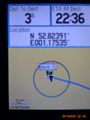
Proof

Track Log

Achievements
Sourcerer earned the OpenStreetMap achievement
|
Sourcerer earned the One Hundredth Expedition in One Graticule
|
Sourcerer earned the Last man standing achievement
|
Expeditions and Plans
| 2015-02-05 | ||
|---|---|---|
| Norwich, United Kingdom | Sourcerer | In a field a close to the river Bure and Itteringham, Norfolk, UK. |
Sourcerer's Expedition Links
2015-02-03 52 1 - 2015-02-05 52 1 - 2015-02-06 52 1 - KML file download of Sourcerer's expeditions for use with Google Earth.