2015-08-22 53 9

| Sat 22 Aug 2015 in 53,9: 53.6552329, 9.7231957 geohashing.info google osm bing/os kml crox |
Location
Compound around the barracks "Marseille-Kaserne" near the Uetersen Airport.
Participants
Expedition
Originally, I planned to stay at home that day, doing dishes and other tedious stuff grown-ups do. But then this hash came along and so the internet forced me outside once again. I started my glorious expedition cycling north. I wanted to take the road through the forest Klövensteen, but the road was not there. I boldly vibrated my bike over the rubble and continued my way through the beautiful landscape.
The hash is located within the fenced-off compound around some barracks. I guess, I could have asked for admittance, but flying seemed easier. I arrived at the Uetersen airport and signed up for a flight. It was surprisingly easy to explain the concept of geohashing to the pilots, guests and curious bystanders. After a relatively short wait, I was handed a parachute, strapped into the guest seat and taken for a flight.
It. Was. Awesome.
The hash is located right at the end of the airstrip at that day, slightly to north-east. My GPS claimed, we were over the hash pretty much immediately. Either I misread the display or my car-GPS is really inaccurate while airborne. I didn't think long about this problem, since the pilot misunderstood my plans of taking a photo of my GPS' display and instead circled over the hash-site so I could take a photo of the actual hash-location instead. At that point of time I was so busy with screaming I completely forgot about checking the quality of the pictures taken.
After a couple of minutes circling over the hash, we had reached sufficient height to stay airborne for hours. I even was allowed to fly the plane myself.
It. Was. Awesome. Really.
For half an hour I checked the speed, looked out for other aircraft and searched for upwash. The thermal lift actually was that good I had to actively sink due to airspace restrictions. Only then I overused the yaw rudder, paniced and had the pilot take over again. I ran out of money and had to ask to be taken home. Up to that point I felt very much like Indiana Jones [1].
I tried to create a video-log-style report of the expedition, but I seem to be a lousy shot. Still, I uploaded the relevant material. For safety reasons, I had to tape my camera to my knee during take-off and landing, so the perspective pretty much describes a close-up view of my nostrils.
I attended a birthday party so the trip home took place at one o'clock in the morning. I forgot to switch off the GPS. Consequently it had drained it's battery. Due to the clear sky I managed to find the right direction by basic astronavigation. However, the way through the dark forest still was kind of spooky.
Tracklog
Unfortunately, the on-board GPS turned out not to have a memory card in it. As a result, no tracklog was saved.
Photos
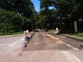
Road under construction
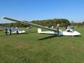
Waiting for a plane
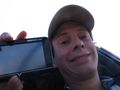
Stupid grin™ with GPS
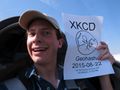
Stupid grin™ with poster
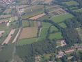
The hashsite from above
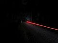
The way back


Note the especially stupid grin due to GPS not being readable.
Also, enjoy these additional aerial shots of the nearby landscape.


Achievements
Whether I actually reached the hash or not clearly is debatable and I cannot supply exact proof. I still award myself with the Air Geohash achievement because we were circling over the hash-site multiple times and for quite some time. I like to think we were in the correct position at least once.
Hermann earned the Air geohash achievement
|