2015-09-19 52 0
| Sat 19 Sep 2015 in Cambridge, UK: 52.3624325, 0.7613624 geohashing.info google osm bing/os kml crox |
Location
On the Icknield Way long distance trail, on a track near Honington Airfield, somewhere between Thetford and Bury St Edmunds.
An initial look on Google Maps doesn't suggest this is a promising hashpoint, with no roads/tracks in the immediate vicinity. But switch to Satellite view, and the hashpoint is at the edge of the field with something that looks very much like a track running alongside. Cross-reference this to an Ordnance Survey map, and the track is in fact part of the Icknield Way long distance trail. Switching back to Google Earth, waymarkers can be seen at the point where the track meets the nearby A134. Furthermore, Google shows a bus stop right at the junction (Rymer Point), with the 84 bus between Bury St Edmunds and Thetford having an hourly service on Saturdays.
Participants
- PaintedJaguar (talk)
- MrsPaintedJaguar
Plans
Currently studying the OS map in detail to see if a walk of an hour or two can be planned in the area taking in the hashpoint. But struggling to come up with anything sensible, so the plans may simply be:
- 1444 train from Cambridge to Bury St Edmunds, giving a four minute connection to...
- 1527 bus from Bury St Edmunds station to Rymer Point (halfway between Ingham an Barnham on the timetable)...
- allowing for 15-20 minutes to walk to the hashpoint, hopefully arriving at 1600...
- and then returning in the same direction, possibly via a pub in Bury St Edmunds for an early evening meal
Expedition
This was a really simple expedition. The only potential area for disaster, the four minute bus-to-train connection, was made with three minutes to spare. The bus driver seemed somewhat shocked when we asked for tickets to Rymer Point, giving us a look that said "but nobody *ever* goes there". The bus did, however, stop exactly where we expected it to, alongside where the Icknield Way crossed the main road.
It was then a straightforward walk alongside fields containing various crops, cows, pigs and the odd pheasant to get to the hashpoint by 4pm. As we got close, we saw that the field to the left of the path had already been harvested, with the farmer busy ploughing, whilst the field on the right was still full of corn. Of course, the hashpoint was to the right of the path, so it was going to be tricky to zero in on the exact point with the farmer nearby. However, the field being ploughed had a hill in it, and the farmer doing the ploughing would disappear out of sight over this hill for a minute or two once every five minutes or so. We had about 25 minutes to hang around at the hashpoint before we had to leave for the return bus, so this gave us four attempts to make a quick dash from the footpath, across a short piece of undergrowth, to the very edge of the cornfield, to see just how close we could get the GPS receiver, before dashing back to the footpath as the farmer returned into view. Ultimately, the final such attempt proved to be the closest approach. We also left a chalk XKCD marker on a nearby telegraph pole, and scratched the letters XKCD into the muddy path, along with an arrow pointing towards the hashpoint.
We then headed back to get the return bus into Bury St Edmunds, which turned out to be the same bus, driven by the same driver, that we'd caught on the way out. This time, we were given a look that said "I didn't think you were going to spend a long time there". After getting back to Bury St Edmunds, we set about the task of finding a pub to visit, which quickly turned into the task of finding a number of pubs to visit, and a very nice pub crawl was had. Unfortunately, none of the pubs we chose served food, so we ended up heading back into Cambridge for a late evening curry on Mill Road to round off the day.
Photos
Start of our walk
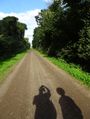
The path
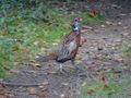
Pheasant
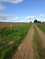
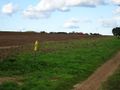
Getting near the hashpoint
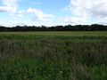
View of the hashpoint
Adjacent field
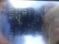
Proof
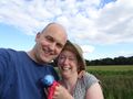
Silly grins
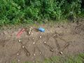
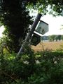
XKCD marker left in path
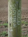
XKCD marker left on telegraph pole


Achievements
PaintedJaguar earned the xkcd Nullaturion achievement
|