2015-12-03 52 1
| Thu 3 Dec 2015 in Norwich, UK: 52.1949943, 1.3030329 geohashing.info google osm bing/os kml crox |
Location
In a copse between Brandeston and Kettleburgh, Suffolk, UK.
Participants
Plans
Expedition one of two spanning midnight - 2015-12-03 52 1 - 2015-12-04 52 1 - ETA 23:05.
Google satellite and street views suggest this might be private and well fenced for horses so access is doubtful.
Expedition
I set out early to get fuel before the pump closed at 10pm so I was 25 minutes ahead of schedule at this hashpoint.
Never give up on a hashpoint. The copse was not fenced. Often a patch of woodland like this is so wet, the land can not be put to any other use. This wood was quite dry but full of tall nettles, thankfully nearly dead with the oncoming winter. There were many rotting branches on the ground so care was needed. The GPS signal was very unstable with a weather front approaching. The patchy signal and fallen branches explain my drunken approach. In the end, I stood still and waited for the signal-drift to give an acceptable distance to the hashpoint. There was very light rain with a stiff breeze and the temperature was about 10 C.
I added the footpath opposite this hashpoint to Open Street Map.
Photos

Google Earth Track.
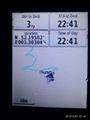
Proof.


Achievements
Sourcerer earned the OpenStreetMap achievement
|
Sourcerer earned the Last man standing achievement
|
Expeditions and Plans
| 2015-12-03 | ||
|---|---|---|
| Norwich, United Kingdom | Sourcerer | In a copse between Brandeston and Kettleburgh, Suffolk, UK. |
Sourcerer's Expedition Links
2015-12-02 52 1 - 2015-12-03 52 1 - 2015-12-04 52 1 - KML file download of Sourcerer's expeditions for use with Google Earth.