2018-05-21 52 1
From Geohashing
| Mon 21 May 2018 in Norwich: 52.7499123, 1.3766712 geohashing.info google osm bing/os kml crox |
Location
A field perimeter track east of the disused airfield at Coltishall, Norfolk, UK.
Participants
Plans
Three of Three - 2018-05-21_52_-0 - 2018-05-21_52_0 - 2018-05-21_52_1
Expedition
This was easy. 375 metres walking along the field perimeter track led right to the hashpoint.
Photos
- Gallery

Arrived. @52.7499,1.3767

Hashpoint. @52.7499,1.3766
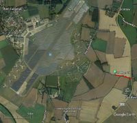
Google Earth Track


Achievements
Sourcerer earned the 2018 Geohashing Day achievement
|
Expeditions and Plans
| 2018-05-21 | ||
|---|---|---|
| Sorocaba, Brazil | Copper | Inside private property within few blocks of Copper's childhood neighborhoo... |
| Pforzheim, Germany | DLichti, a friend | In the forest near Lautenbach. |
| Erfurt, Germany | Reinhard | In a forest between the villages Oberhasel, Teichweiden and Mötzelbach near... |
| Köln, Germany | FelixTheCat | In the forest near Großhau, kreis Düren, Germany. |
| Bonn, Germany | pah | In a forest close to Stadt Blankenberg (Hennef, Germany). |
| Eindhoven, Netherlands | Trevil | In a field east of Gewande, a small town NE of 's Hertogenbosch. |
| Kassel, Germany | GeorgDerReisende | The hash lay between a lake and a lane at Höxter-Godelheim. |
| Northampton, United Kingdom | Sourcerer | Woodland south of Bourne, Lincolnshire, UK. |
| Cambridge, United Kingdom | Sourcerer, Benjw, Tongs/B | West of the Great Ouse, West Lynn, Norfolk, UK. |
| Norwich, United Kingdom | Sourcerer | A field perimeter track east of the disused airfield at Coltishall, Norfolk... |
| Oslo, Norway | Someone went | Somewhere |
| Helsinki, Finland | Someone went | Not published yet |
| Vantaa, Finland | Someone went | Not published yet |
Sourcerer's Expedition Links
2018-05-21_52_0 - 2018-05-21_52_1 - 2018-05-26_52_-0 - KML file download of Sourcerer's expeditions for use with Google Earth.