2018-11-28 54 13
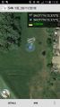
| Wed 28 Nov 2018 in 54,13: 54.0708138, 13.3715948 geohashing.info google osm bing/os kml crox |
Location
In the outskirts of Greifswald. Near a field.
Participants
Plans
In-between the week Hashes are always tricky, but this one is too close to ignore it. I will try to go there in the early afternoon, before the sun sets, since I want to be home again at 16:00 because I want to see the Tie-breaks of the World Chess Championship.
Expedition
When I saw yesterday that today's hash was so close, I started to do all the work I had to do today. At least, get it started. Hashes in the middle of the week are tricky, but when they fall so close you just can't ignore them.
What I did not plan yesterday is that today are the tie-breaks for the World Chess Championship, and I don't want to miss them. So, after class and after eating something, I was starving, I grabbed my bike, Winterbuche, and went for it, with the goal to find it in under one hour. A ninja geohash, nobody will even notice I was there.
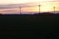
The area where the hash is I know it relatively from previous geocaching expeditions. It is in the outskirts of the hanseatic city of Greifswald, in an industrial park called Herrenhufen. Information about this area is very well explained in the Listing of this geocache.
Once there I had to leave my bike and do the final approach walking. I had to park the bike in a rather dirty area but luckily the path wasn't. I approached the nearby field and walked around it. There I had a nice orange view of the sunset. And between the rather long grass there there appeared as magically a path as if it were made to reach the geohash. There is nothing else there.
While I was checking my phone something moved before me. And as fast as lightning two deer jumped and fled frightened from me. I was fast enough to capture them... on camera ;) In the middle of the field they looked back, but since I was still there, they continued their way far from me.
Ok, now I can follow the path that looks like it was made just enough for this hash, and I was already only 50 meters away. And there I see it. A red tree just in the hash point. I take some pictures of the hash, the tree and its fruits, and the necessary proof. And that's it. I go get my bike and again towards home. All this in just under one hour, as expected. :) And just in time to see the first game of the WCC.
Tracklog

Photos
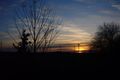
Sunset.
Deer running away. Can you spot them?
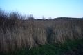
Magical path to the hash.
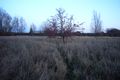
Hashtree in the Hashpoint.
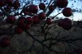
Hasfruits in the Hashtree in the Hashpoint.

Time to go home.
Proof.


Achievements
SastRe.O earned the Land geohash achievement
|
SastRe.O with Winterbuche earned the Bicycle geohash achievement
|
SastRe.O earned the Two to the N achievement
|
SastRe.O earned the OpenStreetMap achievement
|
SastRe.O earned the Ninja geohash achievement
|
SastRe.O earned the Do not disturb achievement
|
The icon is just too perfect for this ribbon.
Other Geohashing Expeditions and Plans on This Day
Expeditions and Plans
| 2018-11-28 | ||
|---|---|---|
| Mannheim, Germany | Kellerkind, his dad | On some farmland north of an industrial area. |
| Kassel, Germany | Digiphono | On a field little west of Hebel |
| Stralsund, Germany | SastRe.O | In the outskirts of Greifswald. Near a field. |
- Meetup on 2018-11-28
- Meetup in 54 13
- Land geohash achievement
- Bicycle geohash achievement
- Two to the N achievement
- OpenStreetMap achievement
- Gratuitous ribbon achievement
- Meetup in Landkreis Vorpommern-Greifswald
- Expeditions by SastRe.O
- SastRe.O's expeditions by bike
- Expeditions
- Expeditions with photos
- Coordinates reached