2019-07-24 54 13
| Wed 24 Jul 2019 in Greifswald, Germany: 54.1259275, 13.5829978 geohashing.info google osm bing/os kml crox |
Location
In the edge of a field near Vierow (Brünzow), MV, Germany.
Participants
Plans
Go there by bike. Grab Winterbuche in the morning, and I expect it to reach the hash and be back home in more or less 4 hours.
Expedition
This is the first hash I can reach in the area of Loisin/Lubmin, on the other side of the Dänische Wieck. So seeing this one being more or less reachable I went for it.
I putted some sunscreen on me and grabbed Winterbuche at 10:19. It was already warm. Since the roads I took are between fields, there weren't many shades where to rest. That's what happens in summer. Well, you can feel it's summer, not only by the temperature, but the amount of tourists. This area (Rügen, Usedom and the coast in general) is a very touristic spot for Germans. I saw lot's of cars from all over Germany, even Dutch and Norwegian ones.
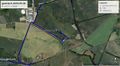
I passed by Kemnitz, Neuendorf, Loissin, Ghalkow and Vierow. Once in Vierow and went towards the industrial port of Vierow. It's a small one. There I started the final approach, which I wasn't so sure how to approach it (which can be seen on the tracklog). I started trying north, but I didn't find any way. There was an area of very tall grass which I didn't feel like crossing it. Manly because it would be to itchy on my legs after it. So I tried south.
There I went along the rail road that goes to the port, and approached the field on its south side. It seemed the correct approach. Here I was closer to the hash. I parked Winterbuche in some grass, and went for the hash. I started going right on the edge of the wheat field. That worked and after a few minutes I was on the hash. There was a Hashtree right on the spot. Took some pictures as proof and went back. There I realized there was a small path on the other side of the field, which I took and made the way back much easier that right on the edge of the field. (I later saw said path on the satellite imagery).
Well, I grabbed Winterbuche again and started my way back home. Before that, thought, I went searching a geocache in Vierow, and after succeeding then I went back home, taking exactly the same roads. 2h50m, better than expected! And no sunburns :)
Tracklog
Close-up


Photos
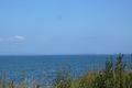
The Baltic Sea. Can you see the Island of Rügen on the horizon?
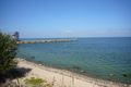
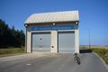
Port of Vierow.
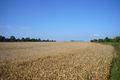
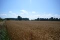
On the edge of this field is the hash. You can see it from here.
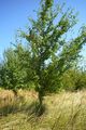
Hashtree.
View from the hashpoint.
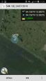
Proof with app.
Winterbuche being welcomed in Vierow.
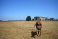
Horse friend I made in Vierow.


Achievements
SastRe.O earned the Land geohash achievement
|
SastRe.O with Winterbuche earned the Bicycle geohash achievement
|
SastRe.O earned the Two to the N achievement
|
Other Geohashing Expeditions and Plans on This Day
Expeditions and Plans
| 2019-07-24 | ||
|---|---|---|
| Frankfurt am Main, Germany | GeorgDerReisende | The hash lay in a thicket at Frankfurt-Sossenheim. |
| Amsterdam, Netherlands | FelixTheCat | Hazerswoude-Rijndijk, municipality of Alphen aan den Rijn, South Holland pr... |
| Stralsund, Germany | SastRe.O | In the edge of a field near Vierow (Brünzow), MV, Germany. |