2019-08-03 45 -118

| Sat 3 Aug 2019 in 45,-118: 45.1760465, -118.1228009 geohashing.info google osm bing/os kml crox |
Location
In the woods south of LaGrande.
Participants
- Michael5000: Expedition #221
Expedition
So, 2019-08-02 45 -120 had left me a few miles outside of Condon. I thought about staying there, but the grocery store closed while I was parking and I was peckish, so I decided to head out across the plateau to Arlington, on the Columbia River, and see what it had on offer. By the time I got to Arlington, I had worked up a vision of a big plate of enchiladas at some Mexican restaurant, so I decided to continue east to Hermeston, where I knew (incorrectly, as it turned out) that I would be able to make that happen.
After dinner (omelette and pie, as it turned out), it was rather late, and rather than drive back through the night to Portland I decided to go to ground. That raised the question of whether there would be any interesting random travel on Saturday. The hashpoint in the Hermeston graticule looked quite doable, but the one in the Pendleton graticule looked like a better than 50/50 chance too. That seemed worth doing, or "worth doing," as I'd never had a win in the Pendleton graticule before.
So! I got up early, and brewed a cup of coffee in the motel room's coffee pot. It yielded a greasy, rust-brown liquid that I poured down the sink without trying, opting instead to buy a fresh cup at a little store at the way out of town. This one tasted like warm dishwater, so I ended up pouring it out too, then stopping halfway to LaGrande to walk and stretch to keep from falling asleep. Finally arriving in LaGrande, I purchased a pair of pants (to avoid a repeat of the 2019-08-02 45 -122 issue) and, finally, a cup of actual coffee.
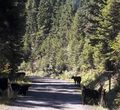
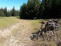
Exit 270 off I-84 goes directly on to a gravel forest road, which wound through the woods and through a herd of insouciant cows. I didn't have any trouble finding the side road and parking. I switched over to bicycle, and started down the side road. My heart was racing! Was it the thrill of geohashing? Not really, it was that I was climbing a very steep hill in first gear. It was a slow ascent, both because of the slope and because there were a lot of downed trees across the abandoned road, but in a while I got to a meadow where I left the bike and walked the last few hundred meters to the hashpoint. It was quiet and peaceful and I was surely the only human around. After the victory celebrations, I set off back to the bicycle. Predictably, when I checked the GPS after a while, I found that I was heading off at about 90 degrees off of the correct direction.
Photos
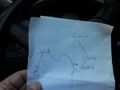
Rigorous planning for the offline environment.
Having left the freeway...
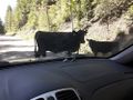
...I soon encountered numerous cows with little sense of right-of-way.
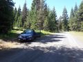
Many miles later, I reached the side road.
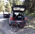
Out comes the secondary vehicle.
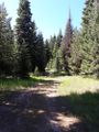
Up the trail.
Leaving the secondary vehicle.

Me, at the hashpoint.
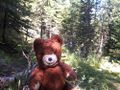
Intrepid mascot.
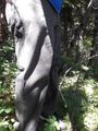
Forest hashpoints require the use of hashpants.


Achievements
- My first win in the Pendleton graticule!
- Second-ever successful expedition (by anyone) to the Pendleton graticule!
Michael5000 earned the Multihash Achievement
|
Michael5000 achieved level 5 of the Minesweeper Geohash achievement
|
Michael5000 achieved level 5 of the Minesweeper Geohash achievement
|