2022-10-14 45 -123

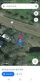
| Fri 14 Oct 2022 in 45,-123: 45.4913024, -123.6492488 geohashing.info google osm bing/os kml crox |
"oh, that was stinging nettle"
This is part 1 of my multihashing expedition, read about part 2 here.
Contents
[hide]Location
Just a few feet of the Wilson River Highway in some trees, probably not on anyone's property but we'll see. I'm glad it fell in the Tillamook State Forest because that opens up plenty of opportunity for distractions and detours.
Participants
- Hamblingreen
- Mi Padre
Plans
I had the day off of school, and my dad had the day off of work so we decided to take a full day and have a geohashing and hiking party all day long. In this two-part multihash (!), the plan is to head down to southeast portland just a few blocks from my cousin's house to reach the Portland hashpoint. From there, my dad and I will set out to the Wilson River Highway in the middle of the Tillamook State Forest to reach the McMinneville hash. We'll hunt for mushrooms on a quick 4 mile hike and head back home. I got to print out two Crox posters this morning, and I can't wait to use them!
Expedition
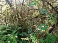
After eating a hardy breakfast of bacon-avacado toast, I printed off the Crox posters for the day. I checked over the "My Backpack" list I made on my profile, and we were off. As we drove through St. Johns toward Hwy 30, I realized I forgot the posters. Again. This is the SECOND TIME I forgot the posters I printed! I even brought the tape and nail to tack up the posters, but not the posters themselves. As we drove across the Saint Johns bridge I asked my dad "wait, where are we going?" Apperently he thought we were going to the Wilson River hash first, so that's the new plan. The drive over to the Tillamook State Forest is uneventful, we left at 10 and got there aronud 11:30 in the morning. After pulling over on the side of the road, I hopped out of the car giddy as I laid my eyes on the challenge before me. The hash is only 20 or so feet off the road, but I needed to trek through thorny blackberries to get the hash right on the dot. And so I did. I got scratched, and at one point I thought I had been scraped by stinging nettle. Despite this adversity, I made it to the hashpoint proud and possibly tresspassing. There was no sign or fence, but it was right next to someone's house, so you be the judge on that one.
Distractions and Detours
Just a little down the highway, there was a logging road (Cedar Butte Rd) with some beautiful vistas that my dad and I decided we'd drive down. I got some beautiful pictures and my first logging road driving experience. I'm glad I remembered my license! It was a one lane gravel road with a cliff on one side and a steep incline on the other. The road had all manner of sharp turns and was challenging but fun to drive. After driving for what felt like forever, we reached a sign declaring that the trailhead we sought was 5.7 miles to the left. We decided to keep going straight because that didn't seem right. Only after another 15 minutes of driving did we turn around and try that road we passed. I'm glad we did, because just around the corner was the trailhead we passed. After parking the truck and grabbing the trail mix, we headed off down the trail.
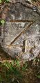
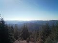
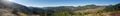
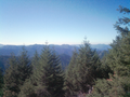
I was not mentally prepared for this hike. After we had concluded our expedition, I realized we had climbed 2600 feet, almost the height of the world's tallest building. The incline was extreme, and since I wore some Vans I had to be careful not to slip. On the way up, we noticed someone cut a "Z" into a few stumps, and my dad's side of the family has a cattle brand depicted as a Z with a cross on the tail. We took a picture of that to send to my grandpa. The view at the top was all worth it. The mountains stretched as far as I could see, and even with the wildfire smoke they were really beautiful. It was at this point as the sun was beating down on me that I realized I needed to add sunscreen to my backpack. We took binoculars and could see burnt stumps on a neighboring butte. There were some benches at the top that we could rest on and recover from our adventure before heading back down the trail.
Photos

there's pain under that smile
watch out for spikey plants!
i swear im not lying
the family cattle brand... in a tree
worth the climb
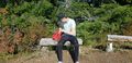
taking a break, wishing for sunscreen
just amazing
beautiful mountains


Achievements
Hamblingreen earned the Multihash Achievement
|