2023-09-18 37 -122
| Mon 18 Sep 2023 in 37,-122: 37.9661578, -122.2637354 geohashing.info google osm bing/os kml crox |
Location
60 m (200 ft) off the Bay Area Ridge Trail in Sobrante Ridge Regional Preserve.
Participants
Plans
Take BART to Richmond, the 74 bus to the foot of the hill, hike up the road and then the trail to the ridgeline. The off-trail hiking to the actual point will probably not be too bad since it's such a short distance.
Expedition
Getting to the base of the hill went pretty straightforwardly. The road up to the entrance to the open space was much steeper than I was expecting, but it still wasn't too bad. The open space was nice and had some good views, even though it was kind of exposed in places and I got a little warm in the sun. Eventually I reached the closest point on the trail to the point, and looked over towards the point. It was again much steeper than I was expecting, but more importantly much shrubbier. I'd already come far enough that I wasn't giving up now, so I dove in. Eventually I reached the point and took my photos, and then headed out. In all, going the 200 meters or so to the point and back had taken me over an hour.
Photos
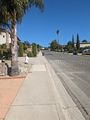
The road up the hill
Entering the open space at the ridge crest
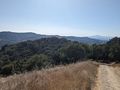
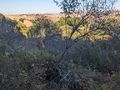
Nice views of the bay from up here on the ridge
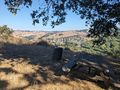
Stopped here for lunch before leaving the trail for the point
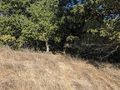
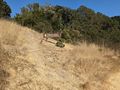
As good a place as any to leave the trail
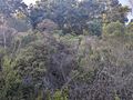
Pretty brushy and steep down here...

Made it!
I see something over there...
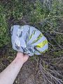
One of these Mylar balloons that get literally everywhere
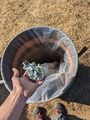
Disposed of

Proof


Achievements
calymsis earned the GeoTrash Geohash Achievement
|
calymsis earned the Public transport geohash achievement
|
calymsis earned the Land geohash achievement
|
calymsis earned the Two to the N achievement
|