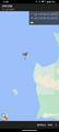
2024-01-27 65 25
| Sat 27 Jan 2024 in 65,25: 65.1762881, 25.2090998 geohashing.info google osm bing/os kml crox |
Location
In the Bay of Bothnia near Haukipudas, 1.1 km from the nearest shore.
The point on a topographic map: [1]
Participants
- Kripakko
- Kripakko's fiancée
Expedition
We went driving in the afternoon so I could go skiing on the sea ice. I did not know the condition of the ice beforehand, but common sense tells that since it has been freezing nearly continuously for three months, the ice will be strong enough to support a skier and likely even a snowmobile. Besides, even in an average winter the whole bay is frozen by the end of January, and this winter has been significantly colder than average so far.
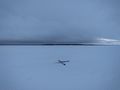
I parked the car on the parking area near the recreation camp of Isoniemi, put on the ski boots and grabbed the skis and ski poles. We walked to the beach, and I prepared myself for skiing to the hashpoint and back. There was some weak ice in the shore perhaps weakened by warm water run from the recreation camp (speculation, I don't actually know). This is what you see as yellow in the second picture. It looked wet, and I would probably have wet the skis had I gone over it, which would quickly have turned the skis into heavy blocks of damp snow, so not good. I found a white good-looking part a little further down the shore, so I went over it without issues and continued skiing towards the hashpoint. It was cloudy and very windy, and the wind was blowing lots of snowflakes around, so all I could see in the direction I was heading for was white.
I did not get very far until two loose dogs of another family came running towards me. The family were able to call them back and catch one of them, but the other one (a silly puppy, as they said) was more interested in me than anything else. It playfully followed me for about half a kilometre, which I did not really mind until I realised that the family were running after it. I was outrunning them by skiing, so I decided to turn back and meet them so they could catch the dog. It took three people, some treats and a substantial amount of time until they were able to catch it, and thereafter I could continue alone. I hope the family learned a lesson about keeping their dogs on a leash. Meanwhile, my fiancée stayed at the shore and took a few pictures of the encounter.
I was going to navigate to the hashpoint using the GPS receiver, but its batteries died in the cold temperature, and I could not revive them with body heat. The batteries should not have been too close to dying yet, but I guess it was too much for them. Oh well, I could use Geohash Droid as a backup, and the phone's battery was not going to die that fast. It was difficult to keep direction with practically no landmarks in sight, but I eventually ended up in the correct coordinates. I spent about ten minutes taking pictures until I left. The temperature was around −3 °C today, and with the strong wind (about 17 m/s on average) it felt more like around −13°C. I did not actually measure the temperature, but at least it was obvious from the consistency of the snow that it was freezing.
The way back was easy because I could see the shore where I left from. It was slowly getting dark since the sun had already set. I skied to the shore and back to the car, and we went on driving back to Oulu. I realised afterwards that I might have been at the hashpoint at 4 pm, the established Saturday meetup time. According to the original plan, I would have been back from the sea well before 4 pm, but the dog encounter caused a big delay. The timestamp of the last picture is 15:58:18, after which I left, but I do not know how soon, so I cannot prove whether I was there at exactly 16:00:00.
Since the GPS receiver died and I did not have tracking in my phone, I do not know the distance that I went. I also do not have a tracklog to meaningfully show. My estimate would be that I skied about 2.8 km in total.
Photos
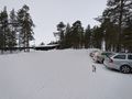
The parking area near the recreation camp.
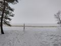
At the shore, 1.15 km to go. Yellow patches are wet, possibly unstable ice.
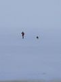
The dog has caught me up and heard the owners' call.
The dog disobeying and zooming to catch me up again.
GPS proof #1

GPS proof #2
X marks the spot. The shore where I left from is there in the background.
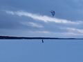
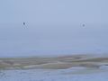
A kiteboarder zooming by on the ice.
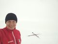
Selfie against the white background (towards the open sea).
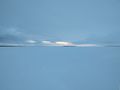
The sun has set there only minutes ago.


Achievements
Kripakko earned the Water geohash achievement
|
Kripakko earned the Walking on water geohash achievement
|
Kripakko earned the Frozen Geohash Achievement
|
Kripakko earned the Two to the N achievement
|