Difference between revisions of "2024-04-24 52 13"
From Geohashing
(init) |
m (subst-ing) |
||
| (3 intermediate revisions by 2 users not shown) | |||
| Line 8: | Line 8: | ||
And DON'T FORGET to add your expedition and the best photo you took to the gallery on the Main Page! We'd love to read your report, but that means we first have to discover it! :) | And DON'T FORGET to add your expedition and the best photo you took to the gallery on the Main Page! We'd love to read your report, but that means we first have to discover it! :) | ||
-->{{meetup graticule | -->{{meetup graticule | ||
| − | | lat= | + | | lat=52 |
| − | | lon= | + | | lon=13 |
| − | | date= | + | | date=2024-04-24 |
}}<!-- edit as necessary --> | }}<!-- edit as necessary --> | ||
== Location == | == Location == | ||
| − | + | Berlin Kreuzberg, just in front of Reichenberger Straße 55 | |
== Participants == | == Participants == | ||
| − | + | * [[User:HeNeArXn|HeNeArXn]] ([[User talk:HeNeArXn|talk]]) | |
| − | |||
| − | |||
| − | |||
| − | |||
== Expedition == | == Expedition == | ||
| − | + | A location in the core city! And it's not in a building, not in a closed back yard, not in some company or railway facilities! | |
| − | + | Accordingly, it was quite straight forward. leave work, U-Bahn to closest stop, walk a few hundred meters, locate hash, walk back. GPS or map was a bit confused and surveyed the location a bit off where I expected it to be, but within a few meters and still on the sidewalk. Pictures are taken from the GPS-location, per map I'd have placed the hash more directly in front of the door in the photo. | |
| − | |||
== Photos == | == Photos == | ||
| Line 33: | Line 28: | ||
--> | --> | ||
<gallery perrow="5"> | <gallery perrow="5"> | ||
| + | Image:2024-04-24 52 13 2.jpg | This door is probably actually the location, taken from GPS point | ||
| + | Image:2024-04-24 52 13 1.jpg | another view from GPS point | ||
| + | Image:2024-04-24 52 14 GPS.png | map | ||
</gallery> | </gallery> | ||
| Line 40: | Line 38: | ||
__NOTOC__ | __NOTOC__ | ||
| − | |||
| − | |||
| − | |||
| − | + | [[Category:Expeditions]] | |
| − | + | [[Category:Expeditions with photos]] | |
| − | |||
| − | [[Category: | ||
| − | |||
| − | |||
| − | |||
| − | |||
| − | |||
| − | |||
| − | |||
| − | |||
| − | |||
| − | |||
| − | |||
| − | |||
[[Category:Coordinates reached]] | [[Category:Coordinates reached]] | ||
| − | + | {{location|DE|BE}} | |
| − | |||
| − | |||
| − | |||
| − | |||
| − | |||
| − | |||
| − | |||
| − | |||
| − | |||
| − | |||
| − | |||
| − | |||
| − | |||
| − | |||
| − | |||
| − | |||
| − | |||
Latest revision as of 21:20, 24 May 2024
| Wed 24 Apr 2024 in 52,13: 52.4960198, 13.4281382 geohashing.info google osm bing/os kml crox |
Location
Berlin Kreuzberg, just in front of Reichenberger Straße 55
Participants
Expedition
A location in the core city! And it's not in a building, not in a closed back yard, not in some company or railway facilities!
Accordingly, it was quite straight forward. leave work, U-Bahn to closest stop, walk a few hundred meters, locate hash, walk back. GPS or map was a bit confused and surveyed the location a bit off where I expected it to be, but within a few meters and still on the sidewalk. Pictures are taken from the GPS-location, per map I'd have placed the hash more directly in front of the door in the photo.
Photos
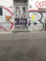
This door is probably actually the location, taken from GPS point
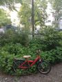
another view from GPS point
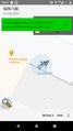
map


