Difference between revisions of "2024-05-15 47 -122"
Coyotebush (talk | contribs) ([live] Up escalator out of service again already. Nearly got run over by an electric scooter on the sidewalk.) |
m (Location) |
||
| (14 intermediate revisions by 4 users not shown) | |||
| Line 1: | Line 1: | ||
| − | |||
| − | |||
| − | |||
| − | |||
| − | |||
| − | |||
{{meetup graticule | {{meetup graticule | ||
| − | | lat= | + | | lat=47 |
| − | | lon= | + | | lon=-122 |
| − | | date= | + | | date=2024-05-15 |
| graticule_name=Seattle | | graticule_name=Seattle | ||
| graticule_link=Seattle, Washington | | graticule_link=Seattle, Washington | ||
| Line 20: | Line 14: | ||
== Participants == | == Participants == | ||
| − | * [[User:Coyotebush| | + | * [[User:Coyotebush|coyotebush]] |
| + | * [[User:...|...]] ([[User talk:...|talk]]) | ||
== Plans == | == Plans == | ||
| − | Same as the first part of [[2024-05-09 47 -122|last week's expedition]], getting off the H Line at the Holden St stop. This part has service every 10 minutes, so I can go whenever I feel like it. 170m walk to point, 40m walk back to northbound stop. | + | * [[User:Coyotebush|coyotebush]]: Same as the first part of [[2024-05-09 47 -122|last week's expedition]], getting off the H Line at the Holden St stop. This part has service every 10 minutes, so I can go whenever I feel like it. 170m walk to point, 40m walk back to northbound stop. |
| + | * [[User:...|...]]: Take the 65, then the Link, then the H Line. | ||
| + | |||
== Expedition == | == Expedition == | ||
| + | === coyotebush === | ||
| + | |||
| + | I felt like it around 3pm. Hoped I could still beat rush hour crowds on the return. | ||
| + | |||
| + | Now that I finally [[2024-03-17 47 -122|learned about the escalator]] at the University Street southwest entrance, I found the up direction blocked off with no notice. Then had a slightly too long and sunny wait for the bus. | ||
| + | *Up escalator out of service again already. Nearly got run over by an electric scooter on the sidewalk. -- [[User:Coyotebush|Coyotebush]] ([[User talk:Coyotebush|talk]]) [https://openstreetmap.org/?mlat=47.60620979&mlon=-122.33524236&zoom=16 @47.6062,-122.3352] 15:32, 15 May 2024 (PDT) | ||
| + | *Had to wait the full 10 minutes for an H Line. -- [[User:Coyotebush|Coyotebush]] ([[User talk:Coyotebush|talk]]) [https://openstreetmap.org/?mlat=47.60449845&mlon=-122.33302652&zoom=16 @47.6045,-122.3330] 15:43, 15 May 2024 (PDT) | ||
| + | |||
| + | Quick walk as expected. As seen in the satellite image, a steady flow of cars waiting to make the tricky left turn off of 21st. GPS reading from the curb was within accuracy range, and a few steps into the tall grass made it even better. Then a few minutes' wait for a return bus. | ||
| + | |||
| + | *Back downtown. -- [[User:Coyotebush|Coyotebush]] ([[User talk:Coyotebush|talk]]) [https://openstreetmap.org/?mlat=47.60428172&mlon=-122.33374208&zoom=16 @47.6043,-122.3337] 16:38, 15 May 2024 (PDT) | ||
| + | |||
| + | Noticed police directing traffic near the stadiums, then discovered light rail was packed with Mariners fans leaving a game. So much for avoiding crowds. | ||
| + | |||
| + | === meetup? === | ||
| + | |||
| + | |||
| + | *If you wanted to meet up at a certain time, I suppose I could delay by stopping for a beverage somewhere first. Otherwise, have fun! -- [[User:Coyotebush|Coyotebush]] ([[User talk:Coyotebush|talk]]) [https://openstreetmap.org/?mlat=47.58555296&mlon=-122.33960966&zoom=16 @47.5856,-122.3396] 15:53, 15 May 2024 (PDT) | ||
| + | |||
| + | *Probably not, unless you want to wait around 'til 5. -- [[User:...|...]] ([[User talk:...|talk]]) | ||
| + | |||
| + | === ... === | ||
| + | |||
| + | |||
| + | *Just hanging out on the bus with a copy of "Uncommon Word Puzzles for the Creative Thinker"; should be at least an hour to the hashpoint. -- [[User:...|...]] ([[User talk:...|talk]]) | ||
| − | |||
== Photos == | == Photos == | ||
<!-- | <!-- | ||
| Line 37: | Line 58: | ||
<gallery perrow="5"> | <gallery perrow="5"> | ||
| + | Image:2024-05-15_47_-122_coyotebush_1715815199726.jpg|From arriving bus [https://openstreetmap.org/?mlat=47.53628611&mlon=-122.36144167&zoom=16 @47.5363,-122.3614] | ||
| + | |||
| + | |||
| + | Image:2024-05-15_47_-122_coyotebush_1715814909819.jpg|From northbound bus stop [https://openstreetmap.org/?mlat=47.53456667&mlon=-122.36063889&zoom=16 @47.5346,-122.3606] | ||
| + | |||
| + | Image:2024-05-15_47_-122_coyotebush_1715814893692.jpg|From crosswalk [https://openstreetmap.org/?mlat=47.53496944&mlon=-122.36076944&zoom=16 @47.5350,-122.3608] | ||
| + | |||
| + | Image:2024-05-15_47_-122_coyotebush_1715814860002.jpg|Standing right on it [https://openstreetmap.org/?mlat=47.53488056&mlon=-122.36075000&zoom=16 @47.5349,-122.3608] | ||
| + | |||
| + | Image:2024-05-15_47_-122_coyotebush_1715814942311.jpg|Map | ||
| + | |||
</gallery> | </gallery> | ||
| Line 42: | Line 74: | ||
== Achievements == | == Achievements == | ||
{{#vardefine:ribbonwidth|100%}} | {{#vardefine:ribbonwidth|100%}} | ||
| + | |||
| + | {{Public transport geohash | latitude = 47 | longitude = -122 | date = 2024-05-15 | name = coyotebush }} | ||
__NOTOC__ | __NOTOC__ | ||
| − | |||
| − | |||
| − | |||
| − | |||
| − | |||
[[Category:Expeditions]] | [[Category:Expeditions]] | ||
[[Category:Expeditions with photos]] | [[Category:Expeditions with photos]] | ||
| − | |||
[[Category:Coordinates reached]] | [[Category:Coordinates reached]] | ||
| − | + | {{location|US|WA|KN}} | |
| − | |||
| − | |||
| − | |||
| − | |||
| − | |||
| − | |||
| − | |||
Latest revision as of 15:43, 28 May 2024
| Wed 15 May 2024 in Seattle: 47.5349050, -122.3607082 geohashing.info google osm bing/os kml crox |
Location
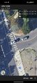
Corner of Delridge Way SW and 21st Ave SW in West Seattle.
Perhaps 1m into some grass, but the adjacent parcel is vacant and doesn't appear to extend to the corner anyway.
Participants
Plans
- coyotebush: Same as the first part of last week's expedition, getting off the H Line at the Holden St stop. This part has service every 10 minutes, so I can go whenever I feel like it. 170m walk to point, 40m walk back to northbound stop.
- ...: Take the 65, then the Link, then the H Line.
Expedition
coyotebush
I felt like it around 3pm. Hoped I could still beat rush hour crowds on the return.
Now that I finally learned about the escalator at the University Street southwest entrance, I found the up direction blocked off with no notice. Then had a slightly too long and sunny wait for the bus.
- Up escalator out of service again already. Nearly got run over by an electric scooter on the sidewalk. -- Coyotebush (talk) @47.6062,-122.3352 15:32, 15 May 2024 (PDT)
- Had to wait the full 10 minutes for an H Line. -- Coyotebush (talk) @47.6045,-122.3330 15:43, 15 May 2024 (PDT)
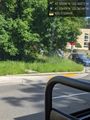
Quick walk as expected. As seen in the satellite image, a steady flow of cars waiting to make the tricky left turn off of 21st. GPS reading from the curb was within accuracy range, and a few steps into the tall grass made it even better. Then a few minutes' wait for a return bus.
- Back downtown. -- Coyotebush (talk) @47.6043,-122.3337 16:38, 15 May 2024 (PDT)
Noticed police directing traffic near the stadiums, then discovered light rail was packed with Mariners fans leaving a game. So much for avoiding crowds.
meetup?
- If you wanted to meet up at a certain time, I suppose I could delay by stopping for a beverage somewhere first. Otherwise, have fun! -- Coyotebush (talk) @47.5856,-122.3396 15:53, 15 May 2024 (PDT)
...
- Just hanging out on the bus with a copy of "Uncommon Word Puzzles for the Creative Thinker"; should be at least an hour to the hashpoint. -- ... (talk)
Photos
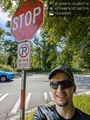
From arriving bus @47.5363,-122.3614
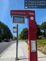
From northbound bus stop @47.5346,-122.3606
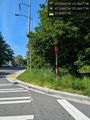
From crosswalk @47.5350,-122.3608
Standing right on it @47.5349,-122.3608
Map


Achievements
coyotebush earned the Public transport geohash achievement
|